


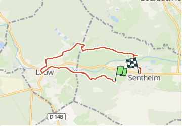
23 03 07 Autour de Sentheim

jmbilger
User

Length
6.4 km

Max alt
398 m

Uphill gradient
71 m
Km-Effort
7.4 km

Min alt
353 m

Downhill gradient
91 m
Boucle
No
Creation date :
2023-03-07 13:24:37.0
Updated on :
2023-03-07 16:01:26.37
1h46
Difficulty : Unknown

FREE GPS app for hiking
 SityTrail
IGN / Geographical institutes
SityTrail Plus
The world is yours!
About
Trail Walking of 6.4 km to be discovered at Grand Est, Haut-Rhin, Sentheim. This trail is proposed by jmbilger.
Positioning
Country:
France
Region :
Grand Est
Department/Province :
Haut-Rhin
Municipality :
Sentheim
Location:
Unknown
Start:(Dec)
Start:(UTM)
353362 ; 5290812 (32T) N.
Comments