


Petit parking entre le Col Amic et Freunstein-FA Freundstein-abri Becherkopf par le GR5 et retour

patrickbeyrath
User
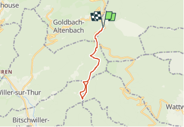

Length
9.7 km

Max alt
952 m

Uphill gradient
287 m
Km-Effort
13.5 km

Min alt
845 m

Downhill gradient
287 m
Boucle
Yes
Creation date :
2023-03-10 06:48:30.546
Updated on :
2023-03-10 08:05:53.411
3h37
Difficulty : Medium

FREE GPS app for hiking
 SityTrail
IGN / Geographical institutes
SityTrail Plus
The world is yours!
About
Trail Walking of 9.7 km to be discovered at Grand Est, Haut-Rhin, Soultz-Haut-Rhin. This trail is proposed by patrickbeyrath.
Positioning
Country:
France
Region :
Grand Est
Department/Province :
Haut-Rhin
Municipality :
Soultz-Haut-Rhin
Location:
Unknown
Start:(Dec)
Start:(UTM)
360042 ; 5303893 (32T) N.
Comments