


Val pralognan

olivieraron
User

Length
30 km

Max alt
2990 m

Uphill gradient
1709 m
Km-Effort
54 km

Min alt
1429 m

Downhill gradient
2249 m
Boucle
No
Creation date :
2023-03-10 21:06:02.0
Updated on :
2023-03-10 21:06:04.161
0m
Difficulty : Easy

FREE GPS app for hiking
 SityTrail
IGN / Geographical institutes
SityTrail Plus
The world is yours!
About
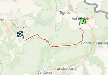
Trail Touring skiing of 30 km to be discovered at Auvergne-Rhône-Alpes, Savoy, Val-d'Isère. This trail is proposed by olivieraron.
Positioning
Country:
France
Region :
Auvergne-Rhône-Alpes
Department/Province :
Savoy
Municipality :
Val-d'Isère
Location:
Unknown
Start:(Dec)
Start:(UTM)
341341 ; 5031547 (32T) N.
Comments