


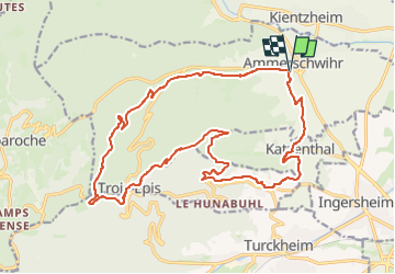
Ammerschwihr Trois Epis

Alain28/01
User

Length
22 km

Max alt
720 m

Uphill gradient
667 m
Km-Effort
30 km

Min alt
236 m

Downhill gradient
666 m
Boucle
Yes
Creation date :
2023-03-15 14:00:38.119
Updated on :
2023-03-15 14:01:55.766
6h54
Difficulty : Very difficult

FREE GPS app for hiking
 SityTrail
IGN / Geographical institutes
SityTrail Plus
The world is yours!
About
Trail Walking of 22 km to be discovered at Grand Est, Haut-Rhin, Ammerschwihr. This trail is proposed by Alain28/01.
Positioning
Country:
France
Region :
Grand Est
Department/Province :
Haut-Rhin
Municipality :
Ammerschwihr
Location:
Unknown
Start:(Dec)
Start:(UTM)
372107 ; 5331529 (32U) N.
Comments