


Sinne Citadelle Pic des Mouches Puits d'Auzon

rlebasque
User
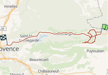

Length
34 km

Max alt
998 m

Uphill gradient
842 m
Km-Effort
46 km

Min alt
225 m

Downhill gradient
1151 m
Boucle
No
Creation date :
2023-03-16 08:10:00.559
Updated on :
2023-03-17 04:57:59.932
20h46
Difficulty : Very difficult

FREE GPS app for hiking
 SityTrail
IGN / Geographical institutes
SityTrail Plus
The world is yours!
About
Trail Walking of 34 km to be discovered at Provence-Alpes-Côte d'Azur, Bouches-du-Rhône, Vauvenargues. This trail is proposed by rlebasque.
Positioning
Country:
France
Region :
Provence-Alpes-Côte d'Azur
Department/Province :
Bouches-du-Rhône
Municipality :
Vauvenargues
Location:
Unknown
Start:(Dec)
Start:(UTM)
717062 ; 4825886 (31T) N.
Comments