Trail Touring skiing Ceillac - Col et tête de la petite part - Photo

Col et tête de la petite part

 tchoua
tchoua

User

© OpenStreetMap contributors
Length
Length
15.7 km
Max alt
Max alt
3111 m
Uphill gradient
Uphill gradient
1421 m
Km-Effort
Km-Effort  
35 km
Min alt
Min alt
1684 m
Downhill gradient
Downhill gradient
1421 m
Boucle
Boucle
Yes
Creation date :
2023-03-17 06:23:00.403
Updated on :
2023-03-24 07:57:37.876

(0 Reviews)

Touring skiing
Touring skiing
3h32
Difficulty : Very difficult

Scan this QR Code to open this trail in the SityTrail application

FREE GPS app for hiking

Logo SityTrail SityTrail

IGN / Geographical institutes

Download SityTrail from the App Store Download SityTrail from Google Play

Logo SityTrail SityTrail World

The world is yours!

Download SityTrail from the App Store Download SityTrail from Google Play Download SityTrail on Huawei AppGallery

About

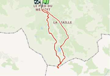
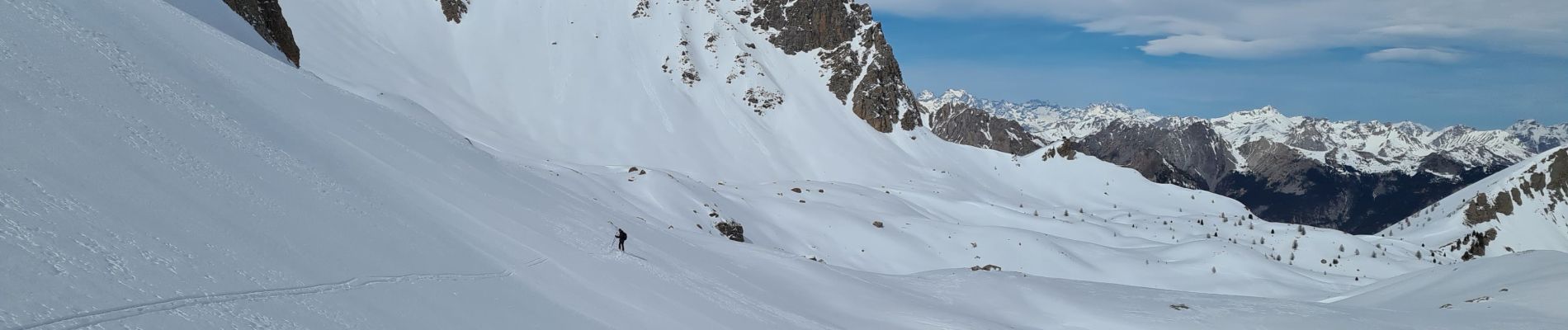
Trail Touring skiing of 15.7 km to be discovered at Provence-Alpes-Côte d'Azur, Hautes-Alpes, Ceillac. This trail is proposed by tchoua.

Description

Belle randonnée à faire à ski depuis ceillac au départ du pied de mélèzet monter directement par les pistes de ski pour arriver au collet st anne ( le tour par chaurionde est trop long) au collet continuer par la droite et faire une traversée ascendante sous les pics des heuviere et de la font sancte,le couloir du col de la petite part est en butée au fond du cirque de St anne  remonter le couloir assez évident large et raide ( pente soutenue) du col on peut monter encore vers la tête de la petite part  à ski  pour la descente au pied du couloir soit reprendre l itinéraire de montée c est à dire à gauche soit continuer tout droit direction col des girardins  et descendre derrière pour rejoindre le vallon du pas de la reine et continuer sur chaurionde

Elevation profile

Photos

Positioning

Country:
France
Region :
Provence-Alpes-Côte d'Azur
Department/Province :
Hautes-Alpes
Municipality :
Ceillac
Location:
Unknown
Start:(UTM)
324887 ; 4946497 (32T) N.

Trails nearby

Trail Walking Ceillac - Crêtes de Chambrettes - Photo
Walking
GUIDE
amiral13

Walking

Medium
(1)
Ceillac, Provence-Alpes-Côte d'Azur, Hautes-Alpes, France
13.4 km | 26 km-effort
5h 53min
Yes
Trail Walking Ceillac - 05 Tour Font Sancte - étape 1 - Photo
Walking
Maryma

Walking

Very difficult
(1)
Ceillac, Provence-Alpes-Côte d'Azur, Hautes-Alpes, France
16.5 km | 36 km-effort
8h 9min
No
Trail Walking Ceillac - Queyras_lac de Clausis - Photo
Walking
MartinBraudThierry

Walking

Very easy
(1)
Ceillac, Provence-Alpes-Côte d'Azur, Hautes-Alpes, France
13.1 km | 26 km-effort
2h 59min
Yes
Trail Walking Ceillac - Ceillac - St Véran - Photo
Walking
GUIDE
romanceline

Walking

Medium
Ceillac, Provence-Alpes-Côte d'Azur, Hautes-Alpes, France
13.5 km | 28 km-effort
7h 22min
No
Trail Walking Ceillac - le Longet ou tête du Rissace - Photo
Walking
GUIDE
amiral13

Walking

Medium
Ceillac, Provence-Alpes-Côte d'Azur, Hautes-Alpes, France
13 km | 25 km-effort
6h 26min
Yes
Trail Walking Ceillac - la pointe de la Saume (traversée) - Photo
Walking
GUIDE
amiral13

Walking

Difficult
Ceillac, Provence-Alpes-Côte d'Azur, Hautes-Alpes, France
15 km | 34 km-effort
6h 43min
No
Trail Walking Ceillac - Lac Ste Anne et Tête de Girardin - Photo
Walking
GUIDE
amiral13

Walking

Medium
Ceillac, Provence-Alpes-Côte d'Azur, Hautes-Alpes, France
14.4 km | 27 km-effort
5h 48min
Yes
Trail Walking Ceillac - lac Sainte Anne - Photo
Walking
griffet

Walking

Easy
(2)
Ceillac, Provence-Alpes-Côte d'Azur, Hautes-Alpes, France
10.7 km | 17.9 km-effort
5h 16min
No
Trail Walking Ceillac - #1 Queyras 3j étape 1 Ceillac - Lac de Roue - Photo
Walking
Liobric

Walking

Very difficult
Ceillac, Provence-Alpes-Côte d'Azur, Hautes-Alpes, France
16.7 km | 33 km-effort
7h 34min
No


Close
My subscriptions