


Ski 17 mars

hairsonsneessens
User
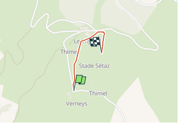

Length
657 m

Max alt
1997 m

Uphill gradient
22 m
Km-Effort
1.1 km

Min alt
1917 m

Downhill gradient
73 m
Boucle
No
Creation date :
2023-03-17 09:24:25.383
Updated on :
2023-03-17 13:34:38.597
4m
Difficulty : Medium

FREE GPS app for hiking
 SityTrail
IGN / Geographical institutes
SityTrail Plus
The world is yours!
About
Trail Alpine skiing of 657 m to be discovered at Auvergne-Rhône-Alpes, Savoy, Valloire. This trail is proposed by hairsonsneessens.
Positioning
Country:
France
Region :
Auvergne-Rhône-Alpes
Department/Province :
Savoy
Municipality :
Valloire
Location:
Unknown
Start:(Dec)
Start:(UTM)
298298 ; 5002481 (32T) N.
Comments