


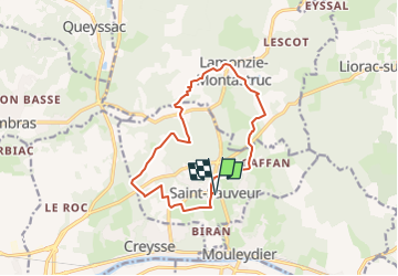
St Sauveur par Lamonzie

JMCMoreau
User

Length
13.1 km

Max alt
132 m

Uphill gradient
225 m
Km-Effort
16.1 km

Min alt
56 m

Downhill gradient
225 m
Boucle
Yes
Creation date :
2023-03-19 07:41:27.843
Updated on :
2023-03-19 07:42:24.518
4h00
Difficulty : Medium

FREE GPS app for hiking
 SityTrail
IGN / Geographical institutes
SityTrail Plus
The world is yours!
About
Trail Walking of 13.1 km to be discovered at New Aquitaine, Dordogne, Saint-Sauveur. This trail is proposed by JMCMoreau.
Positioning
Country:
France
Region :
New Aquitaine
Department/Province :
Dordogne
Municipality :
Saint-Sauveur
Location:
Unknown
Start:(Dec)
Start:(UTM)
309405 ; 4971150 (31T) N.
Comments