


Chateaux de Monbazillac et de Bridoire

JMCMoreau
User
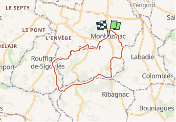

Length
13.6 km

Max alt
178 m

Uphill gradient
225 m
Km-Effort
16.5 km

Min alt
87 m

Downhill gradient
218 m
Boucle
Yes
Creation date :
2023-03-19 16:22:51.413
Updated on :
2023-03-19 16:46:53.304
4h15
Difficulty : Easy

FREE GPS app for hiking
 SityTrail
IGN / Geographical institutes
SityTrail Plus
The world is yours!
About
Trail Walking of 13.6 km to be discovered at New Aquitaine, Dordogne, Monbazillac. This trail is proposed by JMCMoreau.
Positioning
Country:
France
Region :
New Aquitaine
Department/Province :
Dordogne
Municipality :
Monbazillac
Location:
Unknown
Start:(Dec)
Start:(UTM)
301700 ; 4963226 (31T) N.
Comments