


Trace M2 Conchez Guy

mitch1952
User
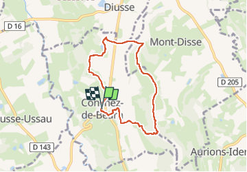

Length
7 km

Max alt
262 m

Uphill gradient
193 m
Km-Effort
9.6 km

Min alt
144 m

Downhill gradient
195 m
Boucle
Yes
Creation date :
2023-03-22 12:53:03.0
Updated on :
2023-03-22 15:20:28.438
2h26
Difficulty : Unknown

FREE GPS app for hiking
 SityTrail
IGN / Geographical institutes
SityTrail Plus
The world is yours!
About
Trail Walking of 7 km to be discovered at New Aquitaine, Pyrénées-Atlantiques, Conchez-de-Béarn. This trail is proposed by mitch1952.
Positioning
Country:
France
Region :
New Aquitaine
Department/Province :
Pyrénées-Atlantiques
Municipality :
Conchez-de-Béarn
Location:
Unknown
Start:(Dec)
Start:(UTM)
728658 ; 4825233 (30T) N.
Comments