


le massif du taennchel

flux99
User
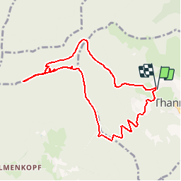

Length
8.5 km

Max alt
977 m

Uphill gradient
443 m
Km-Effort
14.4 km

Min alt
555 m

Downhill gradient
442 m
Boucle
Yes
Creation date :
2014-12-10 00:00:00.0
Updated on :
2014-12-10 00:00:00.0
4h15
Difficulty : Medium

FREE GPS app for hiking
 SityTrail
IGN / Geographical institutes
SityTrail Plus
The world is yours!
About
Trail Walking of 8.5 km to be discovered at Grand Est, Haut-Rhin, Thannenkirch. This trail is proposed by flux99.
Description
visite les trois tables,les reptiles,rocher des géants,le rocher des titants
Photos


Positioning
Country:
France
Region :
Grand Est
Department/Province :
Haut-Rhin
Municipality :
Thannenkirch
Location:
Unknown
Start:(Dec)
Start:(UTM)
373451 ; 5343770 (32U) N.
Comments