


Serre la croix par le cerf et le loup

orsel
User GUIDE
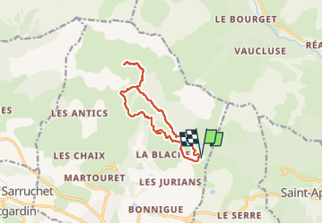

Length
12.1 km

Max alt
1883 m

Uphill gradient
553 m
Km-Effort
19.5 km

Min alt
1400 m

Downhill gradient
553 m
Boucle
Yes
Creation date :
2023-03-25 08:49:00.653
Updated on :
2023-03-25 17:41:11.35
3h00
Difficulty : Easy

FREE GPS app for hiking
 SityTrail
IGN / Geographical institutes
SityTrail Plus
The world is yours!
About
Trail Walking of 12.1 km to be discovered at Provence-Alpes-Côte d'Azur, Hautes-Alpes, Chorges. This trail is proposed by orsel.
Description
depuis le Pomeyret
Positioning
Country:
France
Region :
Provence-Alpes-Côte d'Azur
Department/Province :
Hautes-Alpes
Municipality :
Chorges
Location:
Unknown
Start:(Dec)
Start:(UTM)
286821 ; 4938116 (32T) N.
Comments