Trail Walking Gaujac - Gaujac 160323 - Photo

Gaujac 160323

 fario
fario

User

© OpenStreetMap contributors
Length
Length
11 km
Max alt
Max alt
280 m
Uphill gradient
Uphill gradient
247 m
Km-Effort
Km-Effort  
14.3 km
Min alt
Min alt
114 m
Downhill gradient
Downhill gradient
248 m
Boucle
Boucle
Yes
Creation date :
2023-03-16 08:15:46.237
Updated on :
2023-04-05 14:35:11.361

(0 Reviews)

Walking
Walking
3h15
Difficulty : Difficult

Scan this QR Code to open this trail in the SityTrail application

FREE GPS app for hiking

Logo SityTrail SityTrail

IGN / Geographical institutes

Download SityTrail from the App Store Download SityTrail from Google Play

Logo SityTrail SityTrail World

The world is yours!

Download SityTrail from the App Store Download SityTrail from Google Play Download SityTrail on Huawei AppGallery

About

Trail Walking of 11 km to be discovered at Occitania, Gard, Gaujac. This trail is proposed by fario.

Description

Rando toujours aussi sympa avec l'Oppidum de Gaujac, la chappelle St Saturnin et la visite de Gaujac .

Elevation profile

Photos

Positioning

Country:
France
Region :
Occitania
Department/Province :
Gard
Municipality :
Gaujac
Location:
Unknown
Start:(UTM)
626598 ; 4881707 (31T) N.

Trails nearby

Trail Walking Pouzilhac - Le sentier botanique - Pouzilhac - Photo
Walking
tracegps

Walking

Difficult
(4)
Pouzilhac, Occitania, Gard, France
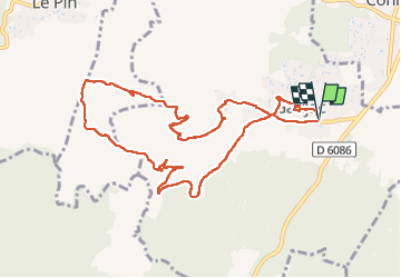
11.3 km | 14 km-effort
3h 30min
Yes
Trail Walking La Capelle-et-Masmolène - Masmolène et l'étang de la Capelle - Photo
Walking
jesusmarieclaire

Walking

Very easy
(1)
La Capelle-et-Masmolène, Occitania, Gard, France
14.4 km | 16.8 km-effort
3h 37min
No
Trail Walking Tresques - Autour de Tresques - Photo
Walking
tracegps

Walking

Medium
(1)
Tresques, Occitania, Gard, France
4.9 km | 5.6 km-effort
2h 0min
Yes
Trail Walking La Capelle-et-Masmolène - La Capelle-et-Masmolène - Photo
Walking
Gegetop

Walking

Easy
La Capelle-et-Masmolène, Occitania, Gard, France
7.7 km | 9.1 km-effort
2h 8min
Yes
Trail Walking Cavillargues - Cavillargues  - Photo
Walking
GUIDE
Roger Philippe Wallez

Walking

Very difficult
Cavillargues, Occitania, Gard, France
22 km | 27 km-effort
7h 2min
Yes
Trail Walking La Capelle-et-Masmolène - la Capelle Masmolène - Photo
Walking
GUIDE
nadinebondoux

Walking

Medium
La Capelle-et-Masmolène, Occitania, Gard, France
16.8 km | 21 km-effort
5h 45min
Yes
Trail Walking Saint-Victor-la-Coste - Saint victor la coste 300323 - Photo
Walking
fario

Walking

Very difficult
Saint-Victor-la-Coste, Occitania, Gard, France
14.7 km | 19.4 km-effort
4h 24min
Yes
Trail Walking Le Pin - Le pin , la Garbie et oppidum - Photo
Walking
jcguew

Walking

Medium
Le Pin, Occitania, Gard, France
6.3 km | 8.3 km-effort
2h 42min
No
Trail Walking Saint-Victor-la-Coste - St Victor la Coste Goule de Navet - Photo
Walking
Manoune

Walking

Medium
Saint-Victor-la-Coste, Occitania, Gard, France
16.4 km | 22 km-effort
5h 47min
Yes


Close
My subscriptions