


Rando du 27 Mars 2023

dudu79
User
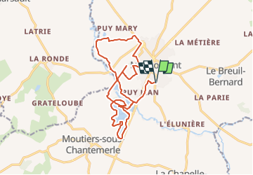

Length
18.2 km

Max alt
202 m

Uphill gradient
151 m
Km-Effort
20 km

Min alt
156 m

Downhill gradient
151 m
Boucle
Yes
Creation date :
2023-03-27 06:30:56.032
Updated on :
2023-03-27 06:31:31.973
4h35
Difficulty : Very difficult

FREE GPS app for hiking
 SityTrail
IGN / Geographical institutes
SityTrail Plus
The world is yours!
About
Trail Walking of 18.2 km to be discovered at New Aquitaine, Deux-Sèvres, Moncoutant-sur-Sèvre. This trail is proposed by dudu79.
Positioning
Country:
France
Region :
New Aquitaine
Department/Province :
Deux-Sèvres
Municipality :
Moncoutant-sur-Sèvre
Location:
Moncoutant
Start:(Dec)
Start:(UTM)
684425 ; 5176495 (30T) N.
Comments