


rrrr

JPS73
User
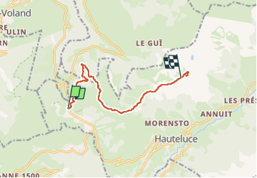

Length
9.5 km

Max alt
1964 m

Uphill gradient
466 m
Km-Effort
14.8 km

Min alt
1662 m

Downhill gradient
200 m
Boucle
No
Creation date :
2023-03-28 08:05:31.868
Updated on :
2023-03-28 14:21:39.72
3h21
Difficulty : Difficult

FREE GPS app for hiking
 SityTrail
IGN / Geographical institutes
SityTrail Plus
The world is yours!
About
Trail Walking of 9.5 km to be discovered at Auvergne-Rhône-Alpes, Savoy, Hauteluce. This trail is proposed by JPS73.
Positioning
Country:
France
Region :
Auvergne-Rhône-Alpes
Department/Province :
Savoy
Municipality :
Hauteluce
Location:
Unknown
Start:(Dec)
Start:(UTM)
308208 ; 5070412 (32T) N.
Comments