Trail Walking Peille - La Lourquiere au départ de la gare de Grave de Peille - Photo

La Lourquiere au départ de la gare de Grave de Peille

 Renefrt
Renefrt

User

© OpenStreetMap contributors
Length
Length
8.5 km
Max alt
Max alt
608 m
Uphill gradient
Uphill gradient
400 m
Km-Effort
Km-Effort  
13.5 km
Min alt
Min alt
244 m
Downhill gradient
Downhill gradient
286 m
Boucle
Boucle
No
Creation date :
2023-03-30 06:54:50.0
Updated on :
2023-05-10 15:27:04.583

(0 Reviews)

Walking
Walking
5h48
Difficulty : Medium

Scan this QR Code to open this trail in the SityTrail application

FREE GPS app for hiking

Logo SityTrail SityTrail

IGN / Geographical institutes

Download SityTrail from the App Store Download SityTrail from Google Play

Logo SityTrail SityTrail World

The world is yours!

Download SityTrail from the App Store Download SityTrail from Google Play Download SityTrail on Huawei AppGallery

About

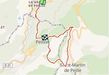
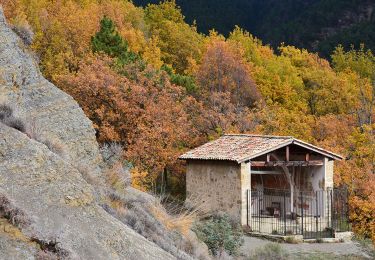
Trail Walking of 8.5 km to be discovered at Provence-Alpes-Côte d'Azur, Maritime Alps, Peille. This trail is proposed by Renefrt.

Description

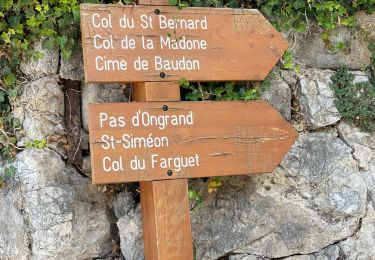
Suivre la direction « Plateau des  Lacs », au retour visite de Peillon.

Elevation profile

Photos

Positioning

Country:
France
Region :
Provence-Alpes-Côte d'Azur
Department/Province :
Maritime Alps
Municipality :
Peille
Location:
Unknown
Start:(UTM)
369654 ; 4850070 (32T) N.

Trails nearby

Trail Walking Peillon - Via Alpina - R161: Peillon > Monaco - Place du Palais - Photo
Walking
tracegps

Walking

Medium
(2)
Peillon, Provence-Alpes-Côte d'Azur, Maritime Alps, France
10.3 km | 16.7 km-effort
2h 49min
No
Trail On foot Peille - Cime de Baudon - Photo
On foot
PRO

On foot

Easy
Peille, Provence-Alpes-Côte d'Azur, Maritime Alps, France
7 km | 14.7 km-effort
3h 20min
Yes
Trail Walking Peille - Cime de Baudon - Photo
Walking
maxcagaze

Walking

Medium
(1)
Peille, Provence-Alpes-Côte d'Azur, Maritime Alps, France
7.8 km | 15.7 km-effort
4h 15min
Yes
Trail Walking L'Escarène - L’Escarene - Photo
Walking
Renefrt

Walking

Easy
L'Escarène, Provence-Alpes-Côte d'Azur, Maritime Alps, France
10.1 km | 13.9 km-effort
4h 39min
Yes
Trail Walking L'Escarène - L'Escarène - Baisse de Bussia - Col de Savel - Chapelle Bon Coeur - Lucéram - Photo
Walking
LtZIP

Walking

Medium
L'Escarène, Provence-Alpes-Côte d'Azur, Maritime Alps, France
18.7 km | 28 km-effort
5h 16min
No
Trail Walking Peille - Peille : Cime du Baudon et Mont Ours - Photo
Walking
ETMU5496

Walking

Very difficult
Peille, Provence-Alpes-Côte d'Azur, Maritime Alps, France
19.9 km | 38 km-effort
5h 46min
Yes
Trail Walking Peille - Peille-Peillon - Photo
Walking
ETMU5496

Walking

Difficult
Peille, Provence-Alpes-Côte d'Azur, Maritime Alps, France
21 km | 34 km-effort
5h 41min
Yes
Trail Walking Peille - Grave de PEILLE - Peillon - Peille - Photo
Walking
GSananes

Walking

Very difficult
Peille, Provence-Alpes-Côte d'Azur, Maritime Alps, France
19.9 km | 33 km-effort
6h 12min
Yes
Trail Walking Drap - Drap-Monaco par la Turbie  - Photo
Walking
coriace

Walking

Easy
Drap, Provence-Alpes-Côte d'Azur, Maritime Alps, France
16 km | 26 km-effort
3h 56min
No


Close
My subscriptions