


La Pointe de l'Aiguille (Auribeau 04)

Clo0413
User
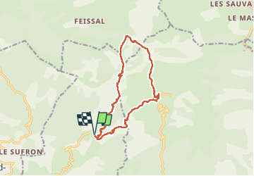

Length
13.7 km

Max alt
1675 m

Uphill gradient
767 m
Km-Effort
24 km

Min alt
1101 m

Downhill gradient
770 m
Boucle
Yes
Creation date :
2023-04-02 07:28:04.544
Updated on :
2023-04-05 16:57:35.978
4h14
Difficulty : Medium

FREE GPS app for hiking
 SityTrail
IGN / Geographical institutes
SityTrail Plus
The world is yours!
About
Trail Walking of 13.7 km to be discovered at Provence-Alpes-Côte d'Azur, Alpes-de-Haute-Provence, Hautes-Duyes. This trail is proposed by Clo0413.
Positioning
Country:
France
Region :
Provence-Alpes-Côte d'Azur
Department/Province :
Alpes-de-Haute-Provence
Municipality :
Hautes-Duyes
Location:
Unknown
Start:(Dec)
Start:(UTM)
274881 ; 4898080 (32T) N.
Comments