


Ouillon le chemin des vergers

mitch1952
User
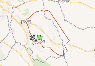

Length
8.1 km

Max alt
337 m

Uphill gradient
69 m
Km-Effort
9 km

Min alt
301 m

Downhill gradient
66 m
Boucle
Yes
Creation date :
2023-04-05 12:07:15.051
Updated on :
2023-04-05 14:31:30.037
2h23
Difficulty : Medium

FREE GPS app for hiking
 SityTrail
IGN / Geographical institutes
SityTrail Plus
The world is yours!
About
Trail Walking of 8.1 km to be discovered at New Aquitaine, Pyrénées-Atlantiques, Ouillon. This trail is proposed by mitch1952.
Positioning
Country:
France
Region :
New Aquitaine
Department/Province :
Pyrénées-Atlantiques
Municipality :
Ouillon
Location:
Unknown
Start:(Dec)
Start:(UTM)
724811 ; 4800110 (30T) N.
Comments