


Mittelwihr - Nécropole de Sigolsheim - Riquewihr - Hunawihr - Zellenberg

VacheKiri67
User
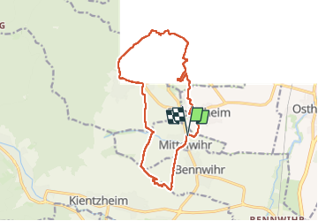

Length
15.1 km

Max alt
382 m

Uphill gradient
356 m
Km-Effort
19.8 km

Min alt
216 m

Downhill gradient
357 m
Boucle
Yes
Creation date :
2023-04-10 08:15:15.982
Updated on :
2023-04-11 16:49:15.769
5h37
Difficulty : Medium

FREE GPS app for hiking
 SityTrail
IGN / Geographical institutes
SityTrail Plus
The world is yours!
About
Trail Walking of 15.1 km to be discovered at Grand Est, Haut-Rhin, Mittelwihr. This trail is proposed by VacheKiri67.
Description
Faite le 10/04/2023 avec nos amis Patrice et Monique.
Au départ de Mittelwihr.
Photos


Positioning
Country:
France
Region :
Grand Est
Department/Province :
Haut-Rhin
Municipality :
Mittelwihr
Location:
Unknown
Start:(Dec)
Start:(UTM)
375147 ; 5334603 (32U) N.
Comments