


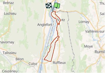
MOTZ SERRIERES: BORDS DU RHONE

djeepee74
User

Length
25 km

Max alt
430 m

Uphill gradient
358 m
Km-Effort
30 km

Min alt
235 m

Downhill gradient
356 m
Boucle
Yes
Creation date :
2023-04-16 06:50:30.652
Updated on :
2023-04-29 15:06:50.419
6h43
Difficulty : Difficult

FREE GPS app for hiking
 SityTrail
IGN / Geographical institutes
SityTrail Plus
The world is yours!
About
Trail Walking of 25 km to be discovered at Auvergne-Rhône-Alpes, Savoy, Motz. This trail is proposed by djeepee74.
Description
BOUCLE... live 20230416
Photos


Positioning
Country:
France
Region :
Auvergne-Rhône-Alpes
Department/Province :
Savoy
Municipality :
Motz
Location:
Unknown
Start:(Dec)
Start:(UTM)
719287 ; 5090438 (31T) N.
Comments