


Trace G2 Lourdios Guy

mitch1952
User
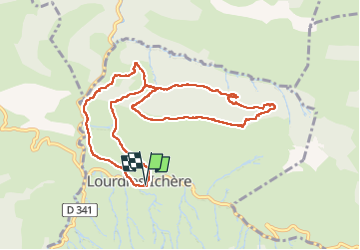

Length
11.8 km

Max alt
983 m

Uphill gradient
644 m
Km-Effort
20 km

Min alt
388 m

Downhill gradient
647 m
Boucle
Yes
Creation date :
2023-04-21 07:25:23.0
Updated on :
2023-04-21 13:36:37.999
6h08
Difficulty : Unknown

FREE GPS app for hiking
 SityTrail
IGN / Geographical institutes
SityTrail Plus
The world is yours!
About
Trail Walking of 11.8 km to be discovered at New Aquitaine, Pyrénées-Atlantiques, Lourdios-Ichère. This trail is proposed by mitch1952.
Positioning
Country:
France
Region :
New Aquitaine
Department/Province :
Pyrénées-Atlantiques
Municipality :
Lourdios-Ichère
Location:
Unknown
Start:(Dec)
Start:(UTM)
690128 ; 4768894 (30T) N.
Comments