


St fauss

DuMarsan
User
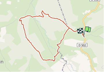

Length
5.4 km

Max alt
326 m

Uphill gradient
200 m
Km-Effort
8.1 km

Min alt
194 m

Downhill gradient
201 m
Boucle
Yes
Creation date :
2023-04-21 13:54:35.97
Updated on :
2023-04-21 16:14:22.119
1h49
Difficulty : Medium

FREE GPS app for hiking
 SityTrail
IGN / Geographical institutes
SityTrail Plus
The world is yours!
About
Trail Walking of 5.4 km to be discovered at New Aquitaine, Pyrénées-Atlantiques, Saint-Faust. This trail is proposed by DuMarsan.
Positioning
Country:
France
Region :
New Aquitaine
Department/Province :
Pyrénées-Atlantiques
Municipality :
Saint-Faust
Location:
Unknown
Start:(Dec)
Start:(UTM)
706437 ; 4795098 (30T) N.
Comments