


les clots les cougnets (5e j)

Danielba
User GUIDE
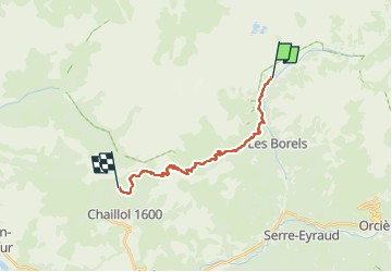

Length
17.9 km

Max alt
2494 m

Uphill gradient
1270 m
Km-Effort
33 km

Min alt
1299 m

Downhill gradient
741 m
Boucle
No
Creation date :
2023-04-22 15:41:14.15
Updated on :
2023-04-22 15:42:32.834
7h31
Difficulty : Very difficult

FREE GPS app for hiking
 SityTrail
IGN / Geographical institutes
SityTrail Plus
The world is yours!
About
Trail Walking of 17.9 km to be discovered at Provence-Alpes-Côte d'Azur, Hautes-Alpes, Champoléon. This trail is proposed by Danielba .
Positioning
Country:
France
Region :
Provence-Alpes-Côte d'Azur
Department/Province :
Hautes-Alpes
Municipality :
Champoléon
Location:
Unknown
Start:(Dec)
Start:(UTM)
282809 ; 4958802 (32T) N.
Comments