


Didenheim

philvor
User
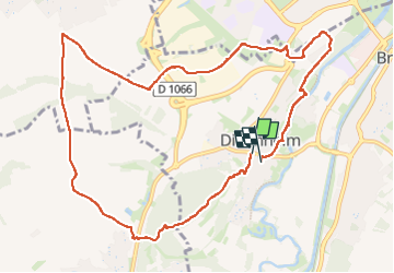

Length
11.2 km

Max alt
341 m

Uphill gradient
214 m
Km-Effort
14.1 km

Min alt
239 m

Downhill gradient
222 m
Boucle
Yes
Creation date :
2023-04-23 12:13:50.0
Updated on :
2023-04-23 15:20:22.314
3h00
Difficulty : Easy

FREE GPS app for hiking
 SityTrail
IGN / Geographical institutes
SityTrail Plus
The world is yours!
About
Trail Walking of 11.2 km to be discovered at Grand Est, Haut-Rhin, Brunstatt-Didenheim. This trail is proposed by philvor.
Positioning
Country:
France
Region :
Grand Est
Department/Province :
Haut-Rhin
Municipality :
Brunstatt-Didenheim
Location:
Unknown
Start:(Dec)
Start:(UTM)
372546 ; 5286344 (32T) N.
Comments