Tour de la Montagne de Robion (Castellane)

Clo0413
User
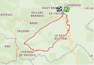

Length
17 km

Max alt
1174 m

Uphill gradient
773 m
Km-Effort
27 km

Min alt
725 m

Downhill gradient
769 m
Boucle
Yes
Creation date :
2023-04-24 07:21:10.239
Updated on :
2023-05-03 17:28:56.309
5h13
Difficulty : Medium

FREE GPS app for hiking
 SityTrail
IGN / Geographical institutes
SityTrail Plus
The world is yours!
About
Trail Walking of 17 km to be discovered at Provence-Alpes-Côte d'Azur, Alpes-de-Haute-Provence, Castellane. This trail is proposed by Clo0413.
Positioning
Country:
France
Region :
Provence-Alpes-Côte d'Azur
Department/Province :
Alpes-de-Haute-Provence
Municipality :
Castellane
Location:
Unknown
Start:(Dec)
Start:(UTM)
299031 ; 4856733 (32T) N.
Comments