


Tor des Géants

attitude73
User
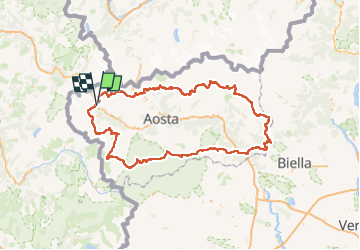

Length
340 km

Max alt
3291 m

Uphill gradient
25050 m
Km-Effort
674 km

Min alt
313 m

Downhill gradient
25055 m
Boucle
Yes
Creation date :
2023-04-26 17:57:28.231
Updated on :
2023-04-26 19:31:44.26
153h07
Difficulty : Very difficult

FREE GPS app for hiking
 SityTrail
IGN / Geographical institutes
SityTrail Plus
The world is yours!
About
Trail Walking of 340 km to be discovered at Aosta Valley, Unknown, Courmayeur. This trail is proposed by attitude73.
Positioning
Country:
Italy
Region :
Aosta Valley
Department/Province :
Unknown
Municipality :
Courmayeur
Location:
Unknown
Start:(Dec)
Start:(UTM)
342419 ; 5072868 (32T) N.
Comments