Trail Walking Nogent-sur-Oise - nogentaise - Photo
© OpenStreetMap contributors
Length
Length
13.4 km
Max alt
Max alt
105 m
Uphill gradient
Uphill gradient
167 m
Km-Effort
Km-Effort  
15.6 km
Min alt
Min alt
31 m
Downhill gradient
Downhill gradient
165 m
Boucle
Boucle
Yes
Creation date :
2023-04-27 11:48:38.849
Updated on :
2023-04-27 15:52:55.459

(0 Reviews)

Walking
Walking
4h03
Difficulty : Difficult

Scan this QR Code to open this trail in the SityTrail application

FREE GPS app for hiking

Logo SityTrail SityTrail

IGN / Geographical institutes

Download SityTrail from the App Store Download SityTrail from Google Play

Logo SityTrail SityTrail World

The world is yours!

Download SityTrail from the App Store Download SityTrail from Google Play Download SityTrail on Huawei AppGallery

About

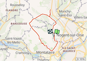
Trail Walking of 13.4 km to be discovered at Hauts-de-France, Oise, Nogent-sur-Oise. This trail is proposed by Cécilia Taffou .

Elevation profile

Photos

23 photos in total. Please click on a photo to see them all in the gallery.

Positioning

Country:
France
Region :
Hauts-de-France
Department/Province :
Oise
Municipality :
Nogent-sur-Oise
Location:
Unknown
Start:(UTM)
459721 ; 5457620 (31U) N.

Trails nearby

Trail Walking Apremont - apremont 60300 - Photo
Walking
dartoisclaude

Walking

Difficult
(1)
Apremont, Hauts-de-France, Oise, France
20 km | 23 km-effort
4h 49min
Yes
Trail Mountain bike Montataire - Rando des Forges 2012 - Montataire - Photo
Mountain bike
tracegps

Mountain bike

Medium
(1)
Montataire, Hauts-de-France, Oise, France
43 km | 51 km-effort
2h 30min
Yes
Trail Walking Saint-Vaast-lès-Mello - 18 randonnée des carrières  - Photo
Walking
fitz2014

Walking

Difficult
Saint-Vaast-lès-Mello, Hauts-de-France, Oise, France
11 km | 12.9 km-effort
2h 49min
Yes
Trail Walking Laigneville - Laigneville-Barisseuse 8k2 - Photo
Walking
Laigneville159-

Walking

Medium
Laigneville, Hauts-de-France, Oise, France
8.2 km | 9.7 km-effort
2h 11min
Yes
Trail sport Monchy-Saint-Éloi - 2022-09-28_13h36m37_<CAC9XJQ5buBJim13UVmX+3WM3tvG2H9PncH-espriqxQdtYHG3Q@mailgmailcom>_chedeville-9kmsgpxchedeville-9kms - Photo
sport
Marc ROUSSELOT

sport

Very easy
Monchy-Saint-Éloi, Hauts-de-France, Oise, France
8 km | 9.5 km-effort
Unknown
Yes
Trail Walking Apremont - 2606 La Haute Pommeraye 7,8km reprise - Photo
Walking
1patrick

Walking

Medium
Apremont, Hauts-de-France, Oise, France
7.8 km | 9.1 km-effort
2h 4min
Yes
Trail Road bike Laigneville - VERBERIE  - Photo
Road bike
Marc ROUSSELOT

Road bike

Very difficult
Laigneville, Hauts-de-France, Oise, France
63 km | 68 km-effort
3h 35min
Yes
Trail Walking Laigneville - Laigneville Rousseloy Randonnée courte - Photo
Walking
La petite semelle Laignevilloise

Walking

Medium
Laigneville, Hauts-de-France, Oise, France
9.6 km | 11.1 km-effort
2h 31min
Yes
Trail Walking Laigneville - Laigneville Rousseloy - Photo
Walking
La petite semelle Laignevilloise

Walking

Difficult
Laigneville, Hauts-de-France, Oise, France
12 km | 14.1 km-effort
3h 12min
Yes


Close
My subscriptions