Trail Walking Nans-les-Pins - Autour du Vieux Nans - Ste.Croix A/R - Photo

Autour du Vieux Nans - Ste.Croix A/R

 rigol05
rigol05

User

© OpenStreetMap contributors
Length
Length
4.8 km
Max alt
Max alt
635 m
Uphill gradient
Uphill gradient
264 m
Km-Effort
Km-Effort  
8.4 km
Min alt
Min alt
394 m
Downhill gradient
Downhill gradient
264 m
Boucle
Boucle
Yes
Creation date :
2023-04-30 09:28:25.828
Updated on :
2023-05-03 09:46:36.271

(0 Reviews)

Walking
Walking
1h54
Difficulty : Medium

Scan this QR Code to open this trail in the SityTrail application

FREE GPS app for hiking

Logo SityTrail SityTrail

IGN / Geographical institutes

Download SityTrail from the App Store Download SityTrail from Google Play

Logo SityTrail SityTrail World

The world is yours!

Download SityTrail from the App Store Download SityTrail from Google Play Download SityTrail on Huawei AppGallery

About

Trail Walking of 4.8 km to be discovered at Provence-Alpes-Côte d'Azur, Var, Nans-les-Pins. This trail is proposed by rigol05.

Description

Sortie du 30-04-2023
Le village ruiné n'est accessible qu'au niveau du panneau indicateur. L'accès par le haut est interdit par un arrêté.

Elevation profile

Positioning

Country:
France
Region :
Provence-Alpes-Côte d'Azur
Department/Province :
Var
Municipality :
Nans-les-Pins
Location:
Unknown
Start:(UTM)
725546 ; 4805578 (31T) N.

Trails nearby

Trail Walking Plan-d'Aups-Sainte-Baume - Sainte Baume 8,5 km - Photo
Walking
GUIDE
rvapeldo

Walking

Medium
(1)
Plan-d'Aups-Sainte-Baume, Provence-Alpes-Côte d'Azur, Var, France
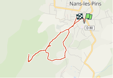
8.4 km | 15.5 km-effort
4h 38min
Yes
Trail Walking Nans-les-Pins - Le baou des glacières - Photo
Walking
GUIDE
amiral13

Walking

Medium
(1)
Nans-les-Pins, Provence-Alpes-Côte d'Azur, Var, France
7.6 km | 12.2 km-effort
4h 27min
Yes
Trail Walking Plan-d'Aups-Sainte-Baume - SityTrail - Sentier merveilleux - La Ste baume - Le Plan d'aups  - Photo
Walking
GUIDE
affinetataille

Walking

Medium
(1)
Plan-d'Aups-Sainte-Baume, Provence-Alpes-Côte d'Azur, Var, France
15 km | 23 km-effort
6h 0min
Yes
Trail Walking Plan-d'Aups-Sainte-Baume - Crêts de la Ste Baume - Photo
Walking
tracegps

Walking

Medium
(2)
Plan-d'Aups-Sainte-Baume, Provence-Alpes-Côte d'Azur, Var, France
15.4 km | 23 km-effort
5h 0min
Yes
Trail Walking Nans-les-Pins - La Croix des Glacières, Sainte-Baume - Photo
Walking
tracegps

Walking

Medium
(1)
Nans-les-Pins, Provence-Alpes-Côte d'Azur, Var, France
7.2 km | 12 km-effort
3h 19min
Yes
Trail Walking Plan-d'Aups-Sainte-Baume - Du Col du Saint-Pilon au Pas de l'Aï, Sainte Baume - Photo
Walking
tracegps

Walking

Medium
(1)
Plan-d'Aups-Sainte-Baume, Provence-Alpes-Côte d'Azur, Var, France
13.1 km | 20 km-effort
5h 15min
Yes
Trail On foot Plan-d'Aups-Sainte-Baume - Massif Sainte Baume et pas de l’Aï 15 km - Photo
On foot
GUIDE
rvapeldo

On foot

Medium
Plan-d'Aups-Sainte-Baume, Provence-Alpes-Côte d'Azur, Var, France
15 km | 22 km-effort
5h 0min
Yes
Trail Walking Plan-d'Aups-Sainte-Baume - Sentier merveilleux - La Ste baume - Le Plan d'aups  - Photo
Walking
GUIDE
affinetataille

Walking

Easy
Plan-d'Aups-Sainte-Baume, Provence-Alpes-Côte d'Azur, Var, France
11.4 km | 15.3 km-effort
4h 0min
Yes
Trail Walking Plan-d'Aups-Sainte-Baume - Source de l'Huveaune depuis l'hôtellerie de la Sainte Baume - Photo
Walking
GUIDE
lhomme.ph

Walking

Medium
(1)
Plan-d'Aups-Sainte-Baume, Provence-Alpes-Côte d'Azur, Var, France
8.6 km | 12.6 km-effort
2h 47min
Yes


Close
My subscriptions