


Compostelle 2023 étape 16 4 mai 2023 Pomps -Sauvelade

Christianlabourie
User
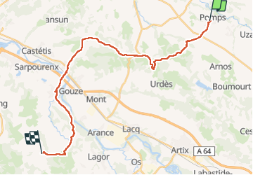

Length
30 km

Max alt
231 m

Uphill gradient
447 m
Km-Effort
36 km

Min alt
72 m

Downhill gradient
464 m
Boucle
No
Creation date :
2023-05-04 06:00:30.937
Updated on :
2023-05-04 15:02:10.763
8h58
Difficulty : Very difficult

FREE GPS app for hiking
 SityTrail
IGN / Geographical institutes
SityTrail Plus
The world is yours!
About
Trail Walking of 30 km to be discovered at New Aquitaine, Pyrénées-Atlantiques, Pomps. This trail is proposed by Christianlabourie.
Positioning
Country:
France
Region :
New Aquitaine
Department/Province :
Pyrénées-Atlantiques
Municipality :
Pomps
Location:
Unknown
Start:(Dec)
Start:(UTM)
698662 ; 4818200 (30T) N.
Comments