


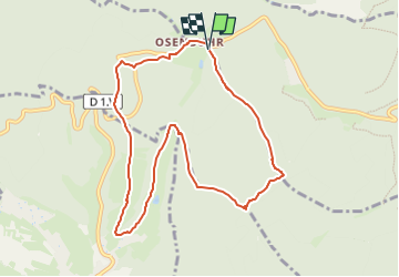
Parking Osenbuhr - Beikenberg - PfaffenheimerTrank - Chemin du Hohberg - Heiligerbaum et retour par la croix rouge

patrickbeyrath
User

Length
8.8 km

Max alt
608 m

Uphill gradient
267 m
Km-Effort
12.3 km

Min alt
423 m

Downhill gradient
263 m
Boucle
Yes
Creation date :
2023-05-05 05:26:25.675
Updated on :
2023-05-05 06:22:29.888
2h47
Difficulty : Easy

FREE GPS app for hiking
 SityTrail
IGN / Geographical institutes
SityTrail Plus
The world is yours!
About
Trail Walking of 8.8 km to be discovered at Grand Est, Haut-Rhin, Gueberschwihr. This trail is proposed by patrickbeyrath.
Positioning
Country:
France
Region :
Grand Est
Department/Province :
Haut-Rhin
Municipality :
Gueberschwihr
Location:
Unknown
Start:(Dec)
Start:(UTM)
368522 ; 5318956 (32U) N.
Comments