Trail Walking Pont-Audemer - Pont-Audemer - autour des étangs - Gare - GD - Photo

Pont-Audemer - autour des étangs - Gare - GD

© OpenStreetMap contributors
Length
Length
9.9 km
Max alt
Max alt
116 m
Uphill gradient
Uphill gradient
137 m
Km-Effort
Km-Effort  
11.7 km
Min alt
Min alt
-2 m
Downhill gradient
Downhill gradient
132 m
Boucle
Boucle
No
Creation date :
2023-05-05 21:57:23.384
Updated on :
2023-05-06 11:58:08.642

(2 Reviews)

Walking
Walking
2h39
Difficulty : Medium

Scan this QR Code to open this trail in the SityTrail application

FREE GPS app for hiking

Logo SityTrail SityTrail

IGN / Geographical institutes

Download SityTrail from the App Store Download SityTrail from Google Play

Logo SityTrail SityTrail World

The world is yours!

Download SityTrail from the App Store Download SityTrail from Google Play Download SityTrail on Huawei AppGallery

About

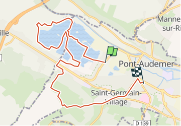
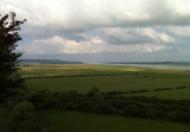
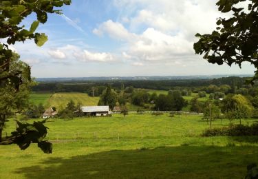
Trail Walking of 9.9 km to be discovered at Normandy, Eure, Pont-Audemer. This trail is proposed by philippe76.

Description

Départ au parking du centre commercial sur la D675.
Prendre le chemin qui mène aux Balastières. Faire le tour des étangs, dans le sens inverse des aiguilles d'une montre. Passer près du camping ainsi que de la Base nautique. Après le passage du petit pont , nous allons traverser la D675, et monter la Côte St-Gilles, puis passer le lieu dit Le Bel-Air. C'est ensuite la partie urbaine de Pont-Audemer pour rejoindre la Gare : Route de Cormeilles, route Jules Ferry,  puis à Droite route de Lisieux. Prendre AG la rue Gallieni pour atteindre Le Bistrot de la Gare.

Elevation profile

Positioning

Country:
France
Region :
Normandy
Department/Province :
Eure
Municipality :
Pont-Audemer
Location:
Pont-Audemer
Start:(UTM)
318551 ; 5470077 (31U) N.

Comments

Please log in to post a review or rate the element


Trails nearby

Trail Walking Tourville-sur-Pont-Audemer - Chemin de la Guinguette - Photo
Walking
bub27

Walking

Difficult
(1)
Tourville-sur-Pont-Audemer, Normandy, Eure, France
9.5 km | 13.2 km-effort
2h 47min
Yes
Trail Mountain bike Saint-Symphorien - Chemin du Vent d'Ouest - Saint-Symphorien - Photo
Mountain bike
tracegps

Mountain bike

Easy
Saint-Symphorien, Normandy, Eure, France
8.7 km | 9.8 km-effort
1h 0min
Yes
Trail Walking Saint-Symphorien - Chemin du Vent d'Ouest - Saint-Symphorien - Photo
Walking
tracegps

Walking

Medium
Saint-Symphorien, Normandy, Eure, France
8.7 km | 9.8 km-effort
2h 19min
Yes
Trail Walking Toutainville - les étangs avec Nolan - Photo
Walking
serisier

Walking

Very easy
Toutainville, Normandy, Eure, France
3.3 km | 3.5 km-effort
58min
Yes
Trail Walking Bouquelon - Bouquelon - Photo
Walking
elcanario

Walking

Very easy
Bouquelon, Normandy, Eure, France
13.2 km | 16.4 km-effort
3h 25min
Yes
Trail Walking Bouquelon - Le phare de la Roque - Bouquelon - Photo
Walking
tracegps

Walking

Medium
Bouquelon, Normandy, Eure, France
19.4 km | 24 km-effort
4h 0min
Yes
Trail Walking Bouquelon - Bouquelon au dessus du Marais Vernier - Photo
Walking
tracegps

Walking

Medium
Bouquelon, Normandy, Eure, France
14.6 km | 17.9 km-effort
2h 49min
Yes
Trail Walking Pont-Audemer - Saint -Germain-Village 2021 10 31_ - Photo
Walking
phiber76

Walking

Medium
Pont-Audemer, Normandy, Eure, France
19.2 km | 25 km-effort
5h 23min
Yes
Trail Walking Pont-Audemer - Pont Audemer au départ du complexe 22 km - Photo
Walking
Marie-Claire-mcp

Walking

Very difficult
Pont-Audemer, Normandy, Eure, France
24 km | 30 km-effort
6h 43min
Yes


Close
My subscriptions