


13-Col de Guiziere

d.rochas
User
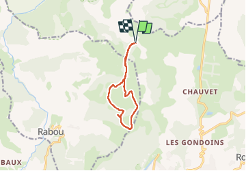

Length
9.8 km

Max alt
1780 m

Uphill gradient
423 m
Km-Effort
15.5 km

Min alt
1502 m

Downhill gradient
424 m
Boucle
Yes
Creation date :
2023-05-06 07:45:29.095
Updated on :
2023-05-06 13:21:58.063
5h34
Difficulty : Medium

FREE GPS app for hiking
 SityTrail
IGN / Geographical institutes
SityTrail Plus
The world is yours!
About
Trail Walking of 9.8 km to be discovered at Provence-Alpes-Côte d'Azur, Hautes-Alpes, Gap. This trail is proposed by d.rochas.
Positioning
Country:
France
Region :
Provence-Alpes-Côte d'Azur
Department/Province :
Hautes-Alpes
Municipality :
Gap
Location:
Gap
Start:(Dec)
Start:(UTM)
265808 ; 4945239 (32T) N.
Comments