


MONT LOUIS - LAC BOUILLOUSES

gallo
User
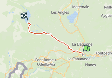

Length
14.8 km

Max alt
2020 m

Uphill gradient
557 m
Km-Effort
21 km

Min alt
1561 m

Downhill gradient
115 m
Boucle
No
Creation date :
2023-05-07 09:14:13.057
Updated on :
2023-05-07 16:58:03.26
4h42
Difficulty : Very difficult

FREE GPS app for hiking
 SityTrail
IGN / Geographical institutes
SityTrail Plus
The world is yours!
About
Trail Walking of 14.8 km to be discovered at Occitania, Pyrénées-Orientales, Mont-Louis. This trail is proposed by gallo.
Positioning
Country:
France
Region :
Occitania
Department/Province :
Pyrénées-Orientales
Municipality :
Mont-Louis
Location:
Unknown
Start:(Dec)
Start:(UTM)
427902 ; 4706539 (31T) N.
Comments