


Gueb-Munster

bernard688
User
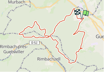

Length
11.7 km

Max alt
660 m

Uphill gradient
437 m
Km-Effort
17.5 km

Min alt
329 m

Downhill gradient
435 m
Boucle
Yes
Creation date :
2023-05-09 10:41:21.228
Updated on :
2023-05-09 15:17:15.423
3h58
Difficulty : Medium

FREE GPS app for hiking
 SityTrail
IGN / Geographical institutes
SityTrail Plus
The world is yours!
About
Trail Walking of 11.7 km to be discovered at Grand Est, Haut-Rhin, Guebwiller. This trail is proposed by bernard688.
Positioning
Country:
France
Region :
Grand Est
Department/Province :
Haut-Rhin
Municipality :
Guebwiller
Location:
Unknown
Start:(Dec)
Start:(UTM)
365211 ; 5308558 (32T) N.
Comments