


Col de Firstplan - La Borne Jaune - Col de Wolfsgrube - Château de Schrankenfels - Château du Haneck - Col du Wolsgrube - Chemin du Pfaffenheimer et de la Borne Jaune - Col de Firstplan

patrickbeyrath
User
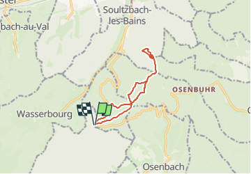

Length
9.7 km

Max alt
792 m

Uphill gradient
260 m
Km-Effort
13.1 km

Min alt
670 m

Downhill gradient
263 m
Boucle
Yes
Creation date :
2023-05-12 05:44:15.555
Updated on :
2023-05-12 06:30:28.571
2h59
Difficulty : Difficult

FREE GPS app for hiking
 SityTrail
IGN / Geographical institutes
SityTrail Plus
The world is yours!
About
Trail Walking of 9.7 km to be discovered at Grand Est, Haut-Rhin, Soultzmatt. This trail is proposed by patrickbeyrath.
Positioning
Country:
France
Region :
Grand Est
Department/Province :
Haut-Rhin
Municipality :
Soultzmatt
Location:
Unknown
Start:(Dec)
Start:(UTM)
364627 ; 5317817 (32T) N.
Comments