


osenbuch schauenberg carrières schrankenfels osenbuch

sit68000
User
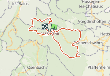

Length
17.1 km

Max alt
813 m

Uphill gradient
617 m
Km-Effort
25 km

Min alt
394 m

Downhill gradient
617 m
Boucle
Yes
Creation date :
2023-05-12 15:06:22.476
Updated on :
2023-05-15 07:09:27.932
2h30
Difficulty : Medium

FREE GPS app for hiking
 SityTrail
IGN / Geographical institutes
SityTrail Plus
The world is yours!
About
Trail Mountain bike of 17.1 km to be discovered at Grand Est, Haut-Rhin, Pfaffenheim. This trail is proposed by sit68000.
Positioning
Country:
France
Region :
Grand Est
Department/Province :
Haut-Rhin
Municipality :
Pfaffenheim
Location:
Unknown
Start:(Dec)
Start:(UTM)
368327 ; 5319034 (32U) N.
Comments