


de CASTEIL à MORA et CABALL MORT

FAUCET
User
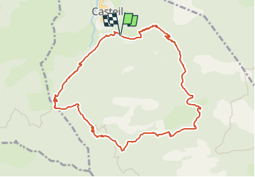

Length
10.9 km

Max alt
1803 m

Uphill gradient
1092 m
Km-Effort
26 km

Min alt
829 m

Downhill gradient
1109 m
Boucle
Yes
Creation date :
2023-05-17 13:10:50.557
Updated on :
2023-05-17 13:10:52.926
5h48
Difficulty : Very difficult

FREE GPS app for hiking
 SityTrail
IGN / Geographical institutes
SityTrail Plus
The world is yours!
About
Trail Walking of 10.9 km to be discovered at Occitania, Pyrénées-Orientales, Casteil. This trail is proposed by FAUCET.
Positioning
Country:
France
Region :
Occitania
Department/Province :
Pyrénées-Orientales
Municipality :
Casteil
Location:
Unknown
Start:(Dec)
Start:(UTM)
450477 ; 4708537 (31T) N.
Comments