


col de jou ,PY ,CABALL MORT

FAUCET
User
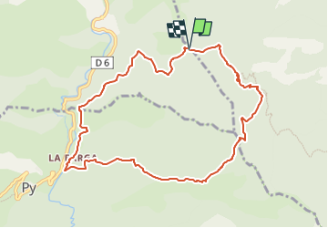

Length
10.5 km

Max alt
1750 m

Uphill gradient
844 m
Km-Effort
22 km

Min alt
934 m

Downhill gradient
836 m
Boucle
Yes
Creation date :
2023-05-17 13:21:44.206
Updated on :
2023-05-17 13:21:46.363
4h56
Difficulty : Very difficult

FREE GPS app for hiking
 SityTrail
IGN / Geographical institutes
SityTrail Plus
The world is yours!
About
Trail Walking of 10.5 km to be discovered at Occitania, Pyrénées-Orientales, Sahorre. This trail is proposed by FAUCET.
Positioning
Country:
France
Region :
Occitania
Department/Province :
Pyrénées-Orientales
Municipality :
Sahorre
Location:
Unknown
Start:(Dec)
Start:(UTM)
449165 ; 4707148 (31T) N.
Comments