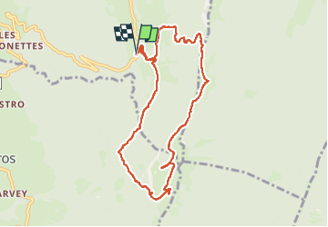
190523 pointe de la Gallopaz

mzonzon05
User


3h21
Difficulty : Easy

FREE GPS app for hiking
 SityTrail
IGN / Geographical institutes
SityTrail Plus
The world is yours!
About
Trail Walking of 9.2 km to be discovered at Auvergne-Rhône-Alpes, Savoy, Thoiry. This trail is proposed by mzonzon05.
Description
Quelle boue ! C'est plutôt rigolo mais il faut rester vigilant.
Une balade entre chemin forestier et sentier avec de jolis chalets d'alpage. restaurés. Aujourd'hui la vue est bouchée mais par beau temps la vue est dégagée sur le Margeriaz et le Collombier d'Aillon que sur la cluse de Chambéry.
Photos


Positioning
Comments