


7 km | 8.8 km-effort

User GUIDE


FREE GPS app for hiking
 SityTrail
IGN / Geographical institutes
SityTrail World
The world is yours!
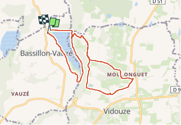
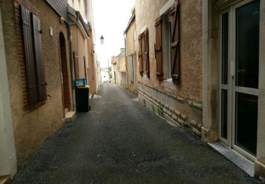
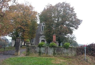
Trail Walking of 10.6 km to be discovered at New Aquitaine, Pyrénées-Atlantiques, Bassillon-Vauzé. This trail is proposed by marmotte65.
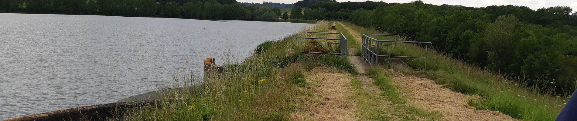
Sympathique balade méconnue ( a part le tour du lac) de tous les adherents presents.
Suite aux importantes chutes de pluie des jours precedent la montée dans le bois a été un peu hasardeuse. on craignait pour le retour dans le meme passage , mais non tout c'est bien passé
5h15 arrêts et PN compris
 "
data-pinterest-text="Pin it"
data-tweet-text="share on twitter"
data-facebook-share-url="https://www.sitytrail.com/en/trails/3665612-bassillonxvauze--bassillon-vauze-g4-xla-passejada-du-loupx----x3665612x/?photo=1#lg=1&slide=1"
data-twitter-share-url="https://www.sitytrail.com/en/trails/3665612-bassillonxvauze--bassillon-vauze-g4-xla-passejada-du-loupx----x3665612x/?photo=1#lg=1&slide=1"
data-googleplus-share-url="https://www.sitytrail.com/en/trails/3665612-bassillonxvauze--bassillon-vauze-g4-xla-passejada-du-loupx----x3665612x/?photo=1#lg=1&slide=1"
data-pinterest-share-url="https://www.sitytrail.com/en/trails/3665612-bassillonxvauze--bassillon-vauze-g4-xla-passejada-du-loupx----x3665612x/?photo=1#lg=1&slide=1">
"
data-pinterest-text="Pin it"
data-tweet-text="share on twitter"
data-facebook-share-url="https://www.sitytrail.com/en/trails/3665612-bassillonxvauze--bassillon-vauze-g4-xla-passejada-du-loupx----x3665612x/?photo=1#lg=1&slide=1"
data-twitter-share-url="https://www.sitytrail.com/en/trails/3665612-bassillonxvauze--bassillon-vauze-g4-xla-passejada-du-loupx----x3665612x/?photo=1#lg=1&slide=1"
data-googleplus-share-url="https://www.sitytrail.com/en/trails/3665612-bassillonxvauze--bassillon-vauze-g4-xla-passejada-du-loupx----x3665612x/?photo=1#lg=1&slide=1"
data-pinterest-share-url="https://www.sitytrail.com/en/trails/3665612-bassillonxvauze--bassillon-vauze-g4-xla-passejada-du-loupx----x3665612x/?photo=1#lg=1&slide=1">
 "
data-pinterest-text="Pin it"
data-tweet-text="share on twitter"
data-facebook-share-url="https://www.sitytrail.com/en/trails/3665612-bassillonxvauze--bassillon-vauze-g4-xla-passejada-du-loupx----x3665612x/?photo=2#lg=1&slide=2"
data-twitter-share-url="https://www.sitytrail.com/en/trails/3665612-bassillonxvauze--bassillon-vauze-g4-xla-passejada-du-loupx----x3665612x/?photo=2#lg=1&slide=2"
data-googleplus-share-url="https://www.sitytrail.com/en/trails/3665612-bassillonxvauze--bassillon-vauze-g4-xla-passejada-du-loupx----x3665612x/?photo=2#lg=1&slide=2"
data-pinterest-share-url="https://www.sitytrail.com/en/trails/3665612-bassillonxvauze--bassillon-vauze-g4-xla-passejada-du-loupx----x3665612x/?photo=2#lg=1&slide=2">
"
data-pinterest-text="Pin it"
data-tweet-text="share on twitter"
data-facebook-share-url="https://www.sitytrail.com/en/trails/3665612-bassillonxvauze--bassillon-vauze-g4-xla-passejada-du-loupx----x3665612x/?photo=2#lg=1&slide=2"
data-twitter-share-url="https://www.sitytrail.com/en/trails/3665612-bassillonxvauze--bassillon-vauze-g4-xla-passejada-du-loupx----x3665612x/?photo=2#lg=1&slide=2"
data-googleplus-share-url="https://www.sitytrail.com/en/trails/3665612-bassillonxvauze--bassillon-vauze-g4-xla-passejada-du-loupx----x3665612x/?photo=2#lg=1&slide=2"
data-pinterest-share-url="https://www.sitytrail.com/en/trails/3665612-bassillonxvauze--bassillon-vauze-g4-xla-passejada-du-loupx----x3665612x/?photo=2#lg=1&slide=2">
 "
data-pinterest-text="Pin it"
data-tweet-text="share on twitter"
data-facebook-share-url="https://www.sitytrail.com/en/trails/3665612-bassillonxvauze--bassillon-vauze-g4-xla-passejada-du-loupx----x3665612x/?photo=3#lg=1&slide=3"
data-twitter-share-url="https://www.sitytrail.com/en/trails/3665612-bassillonxvauze--bassillon-vauze-g4-xla-passejada-du-loupx----x3665612x/?photo=3#lg=1&slide=3"
data-googleplus-share-url="https://www.sitytrail.com/en/trails/3665612-bassillonxvauze--bassillon-vauze-g4-xla-passejada-du-loupx----x3665612x/?photo=3#lg=1&slide=3"
data-pinterest-share-url="https://www.sitytrail.com/en/trails/3665612-bassillonxvauze--bassillon-vauze-g4-xla-passejada-du-loupx----x3665612x/?photo=3#lg=1&slide=3">
"
data-pinterest-text="Pin it"
data-tweet-text="share on twitter"
data-facebook-share-url="https://www.sitytrail.com/en/trails/3665612-bassillonxvauze--bassillon-vauze-g4-xla-passejada-du-loupx----x3665612x/?photo=3#lg=1&slide=3"
data-twitter-share-url="https://www.sitytrail.com/en/trails/3665612-bassillonxvauze--bassillon-vauze-g4-xla-passejada-du-loupx----x3665612x/?photo=3#lg=1&slide=3"
data-googleplus-share-url="https://www.sitytrail.com/en/trails/3665612-bassillonxvauze--bassillon-vauze-g4-xla-passejada-du-loupx----x3665612x/?photo=3#lg=1&slide=3"
data-pinterest-share-url="https://www.sitytrail.com/en/trails/3665612-bassillonxvauze--bassillon-vauze-g4-xla-passejada-du-loupx----x3665612x/?photo=3#lg=1&slide=3">
 "
data-pinterest-text="Pin it"
data-tweet-text="share on twitter"
data-facebook-share-url="https://www.sitytrail.com/en/trails/3665612-bassillonxvauze--bassillon-vauze-g4-xla-passejada-du-loupx----x3665612x/?photo=4#lg=1&slide=4"
data-twitter-share-url="https://www.sitytrail.com/en/trails/3665612-bassillonxvauze--bassillon-vauze-g4-xla-passejada-du-loupx----x3665612x/?photo=4#lg=1&slide=4"
data-googleplus-share-url="https://www.sitytrail.com/en/trails/3665612-bassillonxvauze--bassillon-vauze-g4-xla-passejada-du-loupx----x3665612x/?photo=4#lg=1&slide=4"
data-pinterest-share-url="https://www.sitytrail.com/en/trails/3665612-bassillonxvauze--bassillon-vauze-g4-xla-passejada-du-loupx----x3665612x/?photo=4#lg=1&slide=4">
"
data-pinterest-text="Pin it"
data-tweet-text="share on twitter"
data-facebook-share-url="https://www.sitytrail.com/en/trails/3665612-bassillonxvauze--bassillon-vauze-g4-xla-passejada-du-loupx----x3665612x/?photo=4#lg=1&slide=4"
data-twitter-share-url="https://www.sitytrail.com/en/trails/3665612-bassillonxvauze--bassillon-vauze-g4-xla-passejada-du-loupx----x3665612x/?photo=4#lg=1&slide=4"
data-googleplus-share-url="https://www.sitytrail.com/en/trails/3665612-bassillonxvauze--bassillon-vauze-g4-xla-passejada-du-loupx----x3665612x/?photo=4#lg=1&slide=4"
data-pinterest-share-url="https://www.sitytrail.com/en/trails/3665612-bassillonxvauze--bassillon-vauze-g4-xla-passejada-du-loupx----x3665612x/?photo=4#lg=1&slide=4">
 "
data-pinterest-text="Pin it"
data-tweet-text="share on twitter"
data-facebook-share-url="https://www.sitytrail.com/en/trails/3665612-bassillonxvauze--bassillon-vauze-g4-xla-passejada-du-loupx----x3665612x/?photo=5#lg=1&slide=5"
data-twitter-share-url="https://www.sitytrail.com/en/trails/3665612-bassillonxvauze--bassillon-vauze-g4-xla-passejada-du-loupx----x3665612x/?photo=5#lg=1&slide=5"
data-googleplus-share-url="https://www.sitytrail.com/en/trails/3665612-bassillonxvauze--bassillon-vauze-g4-xla-passejada-du-loupx----x3665612x/?photo=5#lg=1&slide=5"
data-pinterest-share-url="https://www.sitytrail.com/en/trails/3665612-bassillonxvauze--bassillon-vauze-g4-xla-passejada-du-loupx----x3665612x/?photo=5#lg=1&slide=5">
"
data-pinterest-text="Pin it"
data-tweet-text="share on twitter"
data-facebook-share-url="https://www.sitytrail.com/en/trails/3665612-bassillonxvauze--bassillon-vauze-g4-xla-passejada-du-loupx----x3665612x/?photo=5#lg=1&slide=5"
data-twitter-share-url="https://www.sitytrail.com/en/trails/3665612-bassillonxvauze--bassillon-vauze-g4-xla-passejada-du-loupx----x3665612x/?photo=5#lg=1&slide=5"
data-googleplus-share-url="https://www.sitytrail.com/en/trails/3665612-bassillonxvauze--bassillon-vauze-g4-xla-passejada-du-loupx----x3665612x/?photo=5#lg=1&slide=5"
data-pinterest-share-url="https://www.sitytrail.com/en/trails/3665612-bassillonxvauze--bassillon-vauze-g4-xla-passejada-du-loupx----x3665612x/?photo=5#lg=1&slide=5">
 "
data-pinterest-text="Pin it"
data-tweet-text="share on twitter"
data-facebook-share-url="https://www.sitytrail.com/en/trails/3665612-bassillonxvauze--bassillon-vauze-g4-xla-passejada-du-loupx----x3665612x/?photo=6#lg=1&slide=6"
data-twitter-share-url="https://www.sitytrail.com/en/trails/3665612-bassillonxvauze--bassillon-vauze-g4-xla-passejada-du-loupx----x3665612x/?photo=6#lg=1&slide=6"
data-googleplus-share-url="https://www.sitytrail.com/en/trails/3665612-bassillonxvauze--bassillon-vauze-g4-xla-passejada-du-loupx----x3665612x/?photo=6#lg=1&slide=6"
data-pinterest-share-url="https://www.sitytrail.com/en/trails/3665612-bassillonxvauze--bassillon-vauze-g4-xla-passejada-du-loupx----x3665612x/?photo=6#lg=1&slide=6">
"
data-pinterest-text="Pin it"
data-tweet-text="share on twitter"
data-facebook-share-url="https://www.sitytrail.com/en/trails/3665612-bassillonxvauze--bassillon-vauze-g4-xla-passejada-du-loupx----x3665612x/?photo=6#lg=1&slide=6"
data-twitter-share-url="https://www.sitytrail.com/en/trails/3665612-bassillonxvauze--bassillon-vauze-g4-xla-passejada-du-loupx----x3665612x/?photo=6#lg=1&slide=6"
data-googleplus-share-url="https://www.sitytrail.com/en/trails/3665612-bassillonxvauze--bassillon-vauze-g4-xla-passejada-du-loupx----x3665612x/?photo=6#lg=1&slide=6"
data-pinterest-share-url="https://www.sitytrail.com/en/trails/3665612-bassillonxvauze--bassillon-vauze-g4-xla-passejada-du-loupx----x3665612x/?photo=6#lg=1&slide=6">
 "
data-pinterest-text="Pin it"
data-tweet-text="share on twitter"
data-facebook-share-url="https://www.sitytrail.com/en/trails/3665612-bassillonxvauze--bassillon-vauze-g4-xla-passejada-du-loupx----x3665612x/?photo=7#lg=1&slide=7"
data-twitter-share-url="https://www.sitytrail.com/en/trails/3665612-bassillonxvauze--bassillon-vauze-g4-xla-passejada-du-loupx----x3665612x/?photo=7#lg=1&slide=7"
data-googleplus-share-url="https://www.sitytrail.com/en/trails/3665612-bassillonxvauze--bassillon-vauze-g4-xla-passejada-du-loupx----x3665612x/?photo=7#lg=1&slide=7"
data-pinterest-share-url="https://www.sitytrail.com/en/trails/3665612-bassillonxvauze--bassillon-vauze-g4-xla-passejada-du-loupx----x3665612x/?photo=7#lg=1&slide=7">
"
data-pinterest-text="Pin it"
data-tweet-text="share on twitter"
data-facebook-share-url="https://www.sitytrail.com/en/trails/3665612-bassillonxvauze--bassillon-vauze-g4-xla-passejada-du-loupx----x3665612x/?photo=7#lg=1&slide=7"
data-twitter-share-url="https://www.sitytrail.com/en/trails/3665612-bassillonxvauze--bassillon-vauze-g4-xla-passejada-du-loupx----x3665612x/?photo=7#lg=1&slide=7"
data-googleplus-share-url="https://www.sitytrail.com/en/trails/3665612-bassillonxvauze--bassillon-vauze-g4-xla-passejada-du-loupx----x3665612x/?photo=7#lg=1&slide=7"
data-pinterest-share-url="https://www.sitytrail.com/en/trails/3665612-bassillonxvauze--bassillon-vauze-g4-xla-passejada-du-loupx----x3665612x/?photo=7#lg=1&slide=7">
 "
data-pinterest-text="Pin it"
data-tweet-text="share on twitter"
data-facebook-share-url="https://www.sitytrail.com/en/trails/3665612-bassillonxvauze--bassillon-vauze-g4-xla-passejada-du-loupx----x3665612x/?photo=8#lg=1&slide=8"
data-twitter-share-url="https://www.sitytrail.com/en/trails/3665612-bassillonxvauze--bassillon-vauze-g4-xla-passejada-du-loupx----x3665612x/?photo=8#lg=1&slide=8"
data-googleplus-share-url="https://www.sitytrail.com/en/trails/3665612-bassillonxvauze--bassillon-vauze-g4-xla-passejada-du-loupx----x3665612x/?photo=8#lg=1&slide=8"
data-pinterest-share-url="https://www.sitytrail.com/en/trails/3665612-bassillonxvauze--bassillon-vauze-g4-xla-passejada-du-loupx----x3665612x/?photo=8#lg=1&slide=8">
"
data-pinterest-text="Pin it"
data-tweet-text="share on twitter"
data-facebook-share-url="https://www.sitytrail.com/en/trails/3665612-bassillonxvauze--bassillon-vauze-g4-xla-passejada-du-loupx----x3665612x/?photo=8#lg=1&slide=8"
data-twitter-share-url="https://www.sitytrail.com/en/trails/3665612-bassillonxvauze--bassillon-vauze-g4-xla-passejada-du-loupx----x3665612x/?photo=8#lg=1&slide=8"
data-googleplus-share-url="https://www.sitytrail.com/en/trails/3665612-bassillonxvauze--bassillon-vauze-g4-xla-passejada-du-loupx----x3665612x/?photo=8#lg=1&slide=8"
data-pinterest-share-url="https://www.sitytrail.com/en/trails/3665612-bassillonxvauze--bassillon-vauze-g4-xla-passejada-du-loupx----x3665612x/?photo=8#lg=1&slide=8">
 "
data-pinterest-text="Pin it"
data-tweet-text="share on twitter"
data-facebook-share-url="https://www.sitytrail.com/en/trails/3665612-bassillonxvauze--bassillon-vauze-g4-xla-passejada-du-loupx----x3665612x/?photo=9#lg=1&slide=9"
data-twitter-share-url="https://www.sitytrail.com/en/trails/3665612-bassillonxvauze--bassillon-vauze-g4-xla-passejada-du-loupx----x3665612x/?photo=9#lg=1&slide=9"
data-googleplus-share-url="https://www.sitytrail.com/en/trails/3665612-bassillonxvauze--bassillon-vauze-g4-xla-passejada-du-loupx----x3665612x/?photo=9#lg=1&slide=9"
data-pinterest-share-url="https://www.sitytrail.com/en/trails/3665612-bassillonxvauze--bassillon-vauze-g4-xla-passejada-du-loupx----x3665612x/?photo=9#lg=1&slide=9">
"
data-pinterest-text="Pin it"
data-tweet-text="share on twitter"
data-facebook-share-url="https://www.sitytrail.com/en/trails/3665612-bassillonxvauze--bassillon-vauze-g4-xla-passejada-du-loupx----x3665612x/?photo=9#lg=1&slide=9"
data-twitter-share-url="https://www.sitytrail.com/en/trails/3665612-bassillonxvauze--bassillon-vauze-g4-xla-passejada-du-loupx----x3665612x/?photo=9#lg=1&slide=9"
data-googleplus-share-url="https://www.sitytrail.com/en/trails/3665612-bassillonxvauze--bassillon-vauze-g4-xla-passejada-du-loupx----x3665612x/?photo=9#lg=1&slide=9"
data-pinterest-share-url="https://www.sitytrail.com/en/trails/3665612-bassillonxvauze--bassillon-vauze-g4-xla-passejada-du-loupx----x3665612x/?photo=9#lg=1&slide=9">
 "
data-pinterest-text="Pin it"
data-tweet-text="share on twitter"
data-facebook-share-url="https://www.sitytrail.com/en/trails/3665612-bassillonxvauze--bassillon-vauze-g4-xla-passejada-du-loupx----x3665612x/?photo=10#lg=1&slide=10"
data-twitter-share-url="https://www.sitytrail.com/en/trails/3665612-bassillonxvauze--bassillon-vauze-g4-xla-passejada-du-loupx----x3665612x/?photo=10#lg=1&slide=10"
data-googleplus-share-url="https://www.sitytrail.com/en/trails/3665612-bassillonxvauze--bassillon-vauze-g4-xla-passejada-du-loupx----x3665612x/?photo=10#lg=1&slide=10"
data-pinterest-share-url="https://www.sitytrail.com/en/trails/3665612-bassillonxvauze--bassillon-vauze-g4-xla-passejada-du-loupx----x3665612x/?photo=10#lg=1&slide=10">
"
data-pinterest-text="Pin it"
data-tweet-text="share on twitter"
data-facebook-share-url="https://www.sitytrail.com/en/trails/3665612-bassillonxvauze--bassillon-vauze-g4-xla-passejada-du-loupx----x3665612x/?photo=10#lg=1&slide=10"
data-twitter-share-url="https://www.sitytrail.com/en/trails/3665612-bassillonxvauze--bassillon-vauze-g4-xla-passejada-du-loupx----x3665612x/?photo=10#lg=1&slide=10"
data-googleplus-share-url="https://www.sitytrail.com/en/trails/3665612-bassillonxvauze--bassillon-vauze-g4-xla-passejada-du-loupx----x3665612x/?photo=10#lg=1&slide=10"
data-pinterest-share-url="https://www.sitytrail.com/en/trails/3665612-bassillonxvauze--bassillon-vauze-g4-xla-passejada-du-loupx----x3665612x/?photo=10#lg=1&slide=10">
 "
data-pinterest-text="Pin it"
data-tweet-text="share on twitter"
data-facebook-share-url="https://www.sitytrail.com/en/trails/3665612-bassillonxvauze--bassillon-vauze-g4-xla-passejada-du-loupx----x3665612x/?photo=11#lg=1&slide=11"
data-twitter-share-url="https://www.sitytrail.com/en/trails/3665612-bassillonxvauze--bassillon-vauze-g4-xla-passejada-du-loupx----x3665612x/?photo=11#lg=1&slide=11"
data-googleplus-share-url="https://www.sitytrail.com/en/trails/3665612-bassillonxvauze--bassillon-vauze-g4-xla-passejada-du-loupx----x3665612x/?photo=11#lg=1&slide=11"
data-pinterest-share-url="https://www.sitytrail.com/en/trails/3665612-bassillonxvauze--bassillon-vauze-g4-xla-passejada-du-loupx----x3665612x/?photo=11#lg=1&slide=11">
"
data-pinterest-text="Pin it"
data-tweet-text="share on twitter"
data-facebook-share-url="https://www.sitytrail.com/en/trails/3665612-bassillonxvauze--bassillon-vauze-g4-xla-passejada-du-loupx----x3665612x/?photo=11#lg=1&slide=11"
data-twitter-share-url="https://www.sitytrail.com/en/trails/3665612-bassillonxvauze--bassillon-vauze-g4-xla-passejada-du-loupx----x3665612x/?photo=11#lg=1&slide=11"
data-googleplus-share-url="https://www.sitytrail.com/en/trails/3665612-bassillonxvauze--bassillon-vauze-g4-xla-passejada-du-loupx----x3665612x/?photo=11#lg=1&slide=11"
data-pinterest-share-url="https://www.sitytrail.com/en/trails/3665612-bassillonxvauze--bassillon-vauze-g4-xla-passejada-du-loupx----x3665612x/?photo=11#lg=1&slide=11">
 "
data-pinterest-text="Pin it"
data-tweet-text="share on twitter"
data-facebook-share-url="https://www.sitytrail.com/en/trails/3665612-bassillonxvauze--bassillon-vauze-g4-xla-passejada-du-loupx----x3665612x/?photo=12#lg=1&slide=12"
data-twitter-share-url="https://www.sitytrail.com/en/trails/3665612-bassillonxvauze--bassillon-vauze-g4-xla-passejada-du-loupx----x3665612x/?photo=12#lg=1&slide=12"
data-googleplus-share-url="https://www.sitytrail.com/en/trails/3665612-bassillonxvauze--bassillon-vauze-g4-xla-passejada-du-loupx----x3665612x/?photo=12#lg=1&slide=12"
data-pinterest-share-url="https://www.sitytrail.com/en/trails/3665612-bassillonxvauze--bassillon-vauze-g4-xla-passejada-du-loupx----x3665612x/?photo=12#lg=1&slide=12">
"
data-pinterest-text="Pin it"
data-tweet-text="share on twitter"
data-facebook-share-url="https://www.sitytrail.com/en/trails/3665612-bassillonxvauze--bassillon-vauze-g4-xla-passejada-du-loupx----x3665612x/?photo=12#lg=1&slide=12"
data-twitter-share-url="https://www.sitytrail.com/en/trails/3665612-bassillonxvauze--bassillon-vauze-g4-xla-passejada-du-loupx----x3665612x/?photo=12#lg=1&slide=12"
data-googleplus-share-url="https://www.sitytrail.com/en/trails/3665612-bassillonxvauze--bassillon-vauze-g4-xla-passejada-du-loupx----x3665612x/?photo=12#lg=1&slide=12"
data-pinterest-share-url="https://www.sitytrail.com/en/trails/3665612-bassillonxvauze--bassillon-vauze-g4-xla-passejada-du-loupx----x3665612x/?photo=12#lg=1&slide=12">

Walking
Walking
Walking
Walking

On foot

Walking
On foot
Walking
On foot