Trail Walking Fermanville - La vallée des Moulins - RS  - 5 km - Photo

La vallée des Moulins - RS - 5 km

© OpenStreetMap contributors
Length
Length
5 km
Max alt
Max alt
83 m
Uphill gradient
Uphill gradient
124 m
Km-Effort
Km-Effort  
6.6 km
Min alt
Min alt
12 m
Downhill gradient
Downhill gradient
116 m
Boucle
Boucle
Yes
Creation date :
2023-05-20 13:04:28.408
Updated on :
2023-06-12 20:48:26.968

(1 Reviews)

Walking
Walking
1h30
Difficulty : Medium

Scan this QR Code to open this trail in the SityTrail application

FREE GPS app for hiking

Logo SityTrail SityTrail

IGN / Geographical institutes

Download SityTrail from the App Store Download SityTrail from Google Play

Logo SityTrail SityTrail World

The world is yours!

Download SityTrail from the App Store Download SityTrail from Google Play Download SityTrail on Huawei AppGallery

About

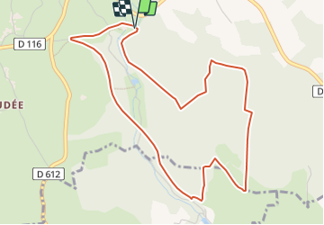
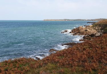
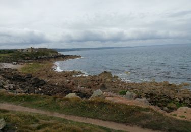
Trail Walking of 5 km to be discovered at Normandy, Manche, Fermanville. This trail is proposed by philippe76.

Description

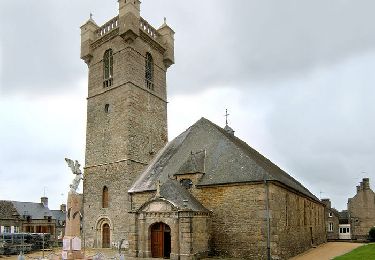
De St Vaast-la-Hougue, prendre la D1 vers Quettehou, puis la D 26 vers Le Vast. Continuer la D26 vers St Pierre l’église. Puis la D210 vers Fermanville. S’arrêter AG sur la D116 , place Marie Ravenel sur la Gauche.
Départ de notre randonnée : Prendre le chemin de l’église. Puis AG, le chemin qui va passer la vallée de la rivière « Le No »  sur le pont. AG suivre l’in*tinéraire carte. AG puis AD le chemin des Argillières. AG la Chasse du curé ; AG la Chasse du Crève-cœur, AG la chasse du Prinses. Suivre l’itinéraire pour rejoindre La Stèle, arrivée de notre randonnée.
Option courte : couper par le chemin des Argilières.

Elevation profile

Positioning

Country:
France
Region :
Normandy
Department/Province :
Manche
Municipality :
Fermanville
Location:
Unknown
Start:(UTM)
611978 ; 5504440 (30U) N.

Comments

Please log in to post a review or rate the element


pb pour traverser la rivière


Trails nearby

Trail Mountain bike Fermanville - Fermanville - Le Vast - Photo
Mountain bike
tracegps

Mountain bike

Difficult
(1)
Fermanville, Normandy, Manche, France
32 km | 37 km-effort
2h 30min
No
Trail Walking Fermanville - La Vallée des Moulins - Photo
Walking
PatRando

Walking

Medium
Fermanville, Normandy, Manche, France
9.1 km | 11 km-effort
2h 30min
Yes
Trail Walking Fermanville - Fermanville - Photo
Walking
PascalN

Walking

Medium
Fermanville, Normandy, Manche, France
17.6 km | 22 km-effort
3h 0min
Yes
Trail Walking Fermanville - Fermanville /  Maupertus - Photo
Walking
PascalN

Walking

Medium
Fermanville, Normandy, Manche, France
21 km | 26 km-effort
3h 36min
Yes
Trail Walking Fermanville - 50 Autour du Cap LEVI 5km  - Photo
Walking
SyMA

Walking

Very easy
Fermanville, Normandy, Manche, France
5.1 km | 5.6 km-effort
1h 22min
Yes
Trail Walking Fermanville - cap levi - Photo
Walking
murph

Walking

Easy
(1)
Fermanville, Normandy, Manche, France
4.4 km | 4.8 km-effort
1h 3min
Yes
Trail Walking Fermanville - fermanville 12042019 - Photo
Walking
AMOURETTE

Walking

Very easy
(1)
Fermanville, Normandy, Manche, France
9.3 km | 11.8 km-effort
2h 4min
Yes
Trail Walking Fermanville - boucle cap Lévy plage mondree  - Photo
Walking
fbienmuller

Walking

Very easy
(1)
Fermanville, Normandy, Manche, France
7 km | 8 km-effort
1h 48min
Yes
Trail Mountain bike Théville - Petite balade dans le val de Saire - Théville - Photo
Mountain bike
tracegps

Mountain bike

Medium
Théville, Normandy, Manche, France
31 km | 37 km-effort
4h 49min
Yes


Close
My subscriptions