![](/images/other/stat-length.png)
![Trail Walking Hannut - HANNUT _ LG _ Marche Fédérale _ 21/05/2023 - Photo](https://media.geolcdn.com/t/1900/400/ext.pjpeg?maxdim=2&url=https%3A%2F%2Fmedia.geolcdn.com%2Ff%2F2b42cf7c-c723-4b11-a4e8-c9052220a2c7.jpg)
HANNUT _ LG _ Marche Fédérale _ 21/05/2023
jeangulu
User
![Length](/images/other/stat-length.png)
Length
21 km
![Max alt](https://static1.geolcdn.com/siteimages/upload/files/1508320355ic_sort_altitude_max_24dp.png)
Max alt
145 m
![Uphill gradient](https://static1.geolcdn.com/siteimages/upload/files/1508320355ic_sort_den_pos_24dp.png)
Uphill gradient
133 m
![Km-Effort](/images/other/stat-length.png)
Km-Effort
23 km
![Min alt](https://static1.geolcdn.com/siteimages/upload/files/1508320355ic_sort_altitude_min_24dp.png)
Min alt
121 m
![Downhill gradient](https://static1.geolcdn.com/siteimages/upload/files/1508320355ic_sort_den_neg_24dp.png)
Downhill gradient
132 m
![Boucle](https://static1.geolcdn.com/siteimages/upload/files/16400158638029165_repeat_loop_refresh_sync_direction_icon.png)
Boucle
Yes
Creation date :
2023-05-21 08:34:07.291
Updated on :
2023-05-21 18:53:04.604
![Walking](https://static1.geolcdn.com/sitytour/trail-icons/101.png)
4h43
Difficulty : Medium
![Scan this QR Code to open this trail in the SityTrail application](https://capi.geolives.com/qq0zvz2zws4bq2lad0pu/sitytour/trails/3668085/qr.png?size=200)
FREE GPS app for hiking
About
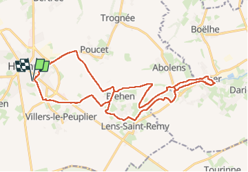
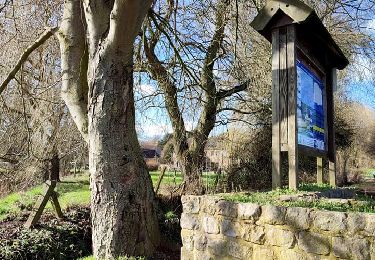
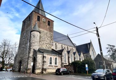
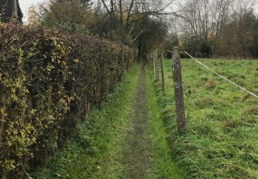
Trail Walking of 21 km to be discovered at Wallonia, Liège, Hannut. This trail is proposed by jeangulu.
Description
Point de départ : Foyer Saint - Christophe ASBL _ Rue Lambert Mottard , 21 - 21 - 4280 - HANNUT.
Organisateur : LG 044 _ LES MARCHEURS DES ECHOS DE LA MEHAIGNE.
Carte IGN ; 41/1.
39* Mache des Lilas
Positioning
Country:
Belgium
Region :
Wallonia
Department/Province :
Liège
Municipality :
Hannut
Location:
Unknown
Start:(Dec)
Start:(UTM)
647114 ; 5614939 (31U) N.
Comments
Trails nearby
![Trail Walking Braives - Boucle Moulin de Velupont - Photo](https://media.geolcdn.com/t/375/260/ext.jpg?maxdim=2&url=https%3A%2F%2Fservices.sitytrail.com%2FGeolivesWS%2FDownloadMedia.ashx%3FTrailID%3D705146%26Media%3Dfix__20170225113122.jpg)
![Walking Walking](https://static1.geolcdn.com/sitytour/trail-icons/101.png)
Boucle Moulin de Velupont
Walking
Very easy
(4)
Braives,
Wallonia,
Liège,
Belgium
![](/images/other/stat-length.png)
4.6 km | 5.2 km-effort
55min
![](https://static1.geolcdn.com/siteimages/upload/files/16400158638029165_repeat_loop_refresh_sync_direction_icon.png)
Yes
![Trail Walking Hannut - La balade des chevées (5km) - Photo](https://media.geolcdn.com/t/375/260/ext.jpg?maxdim=2&url=https%3A%2F%2Fmedia.geolcdn.com%2Ff%2F4f5eaa7c-e24d-4247-898f-e668713f7776.jpg)
![Walking Walking](https://static1.geolcdn.com/sitytour/trail-icons/101.png)
La balade des chevées (5km)
Walking
Easy
(1)
Hannut,
Wallonia,
Liège,
Belgium
![](/images/other/stat-length.png)
5.3 km | 5.7 km-effort
1h 18min
![](https://static1.geolcdn.com/siteimages/upload/files/16400158638029165_repeat_loop_refresh_sync_direction_icon.png)
Yes
![Trail Walking Hannut - La promenade de la Mouhagne - Photo](https://media.geolcdn.com/t/375/260/ext.jpg?maxdim=2&url=https%3A%2F%2Fmedia.geolcdn.com%2Ff%2F992bf509-1491-4136-a1e0-5816e773d65e.jpg)
![Walking Walking](https://static1.geolcdn.com/sitytour/trail-icons/101.png)
La promenade de la Mouhagne
Walking
Medium
(1)
Hannut,
Wallonia,
Liège,
Belgium
![](/images/other/stat-length.png)
7.9 km | 9 km-effort
2h 3min
![](https://static1.geolcdn.com/siteimages/upload/files/16400158638029165_repeat_loop_refresh_sync_direction_icon.png)
Yes
![Trail Walking Hannut - Hannut R3 - Photo](https://media.geolcdn.com/t/375/260/ext.jpg?maxdim=2&url=https%3A%2F%2Fmedia.geolcdn.com%2Ff%2F351999e5-0250-48b0-befe-e572848e7b6f.jpeg)
![Walking Walking](https://static1.geolcdn.com/sitytour/trail-icons/101.png)
![Trail Walking Hannut - Hannut R2 - Photo](https://media.geolcdn.com/t/375/260/ext.jpg?maxdim=2&url=https%3A%2F%2Fmedia.geolcdn.com%2Ff%2F9358d202-85bd-4dba-8039-3673f9a4abc1.jpeg)
![Walking Walking](https://static1.geolcdn.com/sitytour/trail-icons/101.png)
![Trail Walking Hannut - Hannut R1 - Photo](https://media.geolcdn.com/t/375/260/ext.jpg?maxdim=2&url=https%3A%2F%2Fmedia.geolcdn.com%2Ff%2Fa48ae00d-4092-46f8-a66f-79f8591894ca.jpeg)
![Walking Walking](https://static1.geolcdn.com/sitytour/trail-icons/101.png)
![Trail Walking Hannut - Tracé - Photo](https://media.geolcdn.com/t/375/260/ext.jpg?maxdim=2&url=https%3A%2F%2Fmedia.geolcdn.com%2Ff%2F4a497274-894e-4866-9a3b-b1d177ee76d9.jpeg)
![Walking Walking](https://static1.geolcdn.com/sitytour/trail-icons/101.png)
![Trail Walking Hannut - Marche de la fédération à Hannut - Photo](https://media.geolcdn.com/t/375/260/ext.jpg?maxdim=2&url=https%3A%2F%2Fmedia.geolcdn.com%2Ff%2F31a5226e-9416-4ee0-9f2d-9042bd4e66a8.jpg)
![Walking Walking](https://static1.geolcdn.com/sitytour/trail-icons/101.png)
Marche de la fédération à Hannut
Walking
Very easy
Hannut,
Wallonia,
Liège,
Belgium
![](/images/other/stat-length.png)
15.1 km | 16.3 km-effort
2h 44min
![](https://static1.geolcdn.com/siteimages/upload/files/16400158638029165_repeat_loop_refresh_sync_direction_icon.png)
No
![Trail Walking Hannut - Adeps LensStRemy 2016 - Photo](https://media.geolcdn.com/t/375/260/ext.jpg?maxdim=2&url=https%3A%2F%2Fstatic1.geolcdn.com%2Fsiteimages%2Fupload%2Ffiles%2F1553511878bg_sport_marche.png)
![Walking Walking](https://static1.geolcdn.com/sitytour/trail-icons/101.png)
Adeps LensStRemy 2016
Walking
Very easy
(1)
Hannut,
Wallonia,
Liège,
Belgium
![](/images/other/stat-length.png)
11.3 km | 12.2 km-effort
2h 43min
![](https://static1.geolcdn.com/siteimages/upload/files/16400158638029165_repeat_loop_refresh_sync_direction_icon.png)
Yes