Trail Walking Meudon - Meudon val Fleury via h.Sellier - Photo

Meudon val Fleury via h.Sellier

© OpenStreetMap contributors
Length
Length
17.7 km
Max alt
Max alt
173 m
Uphill gradient
Uphill gradient
334 m
Km-Effort
Km-Effort  
22 km
Min alt
Min alt
77 m
Downhill gradient
Downhill gradient
342 m
Boucle
Boucle
Yes
Creation date :
2023-05-23 05:29:50.197
Updated on :
2023-05-23 12:40:52.55

(0 Reviews)

Walking
Walking
6h16
Difficulty : Medium

Scan this QR Code to open this trail in the SityTrail application

FREE GPS app for hiking

Logo SityTrail SityTrail

IGN / Geographical institutes

Download SityTrail from the App Store Download SityTrail from Google Play

Logo SityTrail SityTrail World

The world is yours!

Download SityTrail from the App Store Download SityTrail from Google Play Download SityTrail on Huawei AppGallery

About

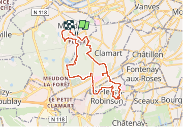
Trail Walking of 17.7 km to be discovered at Ile-de-France, Hauts-de-Seine, Meudon. This trail is proposed by c.chehere.

Description

Depuis la station Meudon Val Fleury

Elevation profile

Photos

Positioning

Country:
France
Region :
Ile-de-France
Department/Province :
Hauts-de-Seine
Municipality :
Meudon
Location:
Unknown
Start:(UTM)
444344 ; 5406367 (31U) N.

Trails nearby

Trail Walking Chaville - Le Sentier des 7 étangs - Photo
Walking
tracegps

Walking

Difficult
(5)
Chaville, Ile-de-France, Hauts-de-Seine, France
23 km | 31 km-effort
5h 0min
Yes
Trail Walking Paris - 010 - Paris - des serres d'Auteuil à Bagatelle  - Photo
Walking
GUIDE
Rui Barbosa

Walking

Difficult
(1)
Paris, Ile-de-France, Paris, France
12.3 km | 14 km-effort
3h 10min
No
Trail Walking Paris - DP75-13 De Vaugirard à Sèvres-Babylone - Photo
Walking
clalaur

Walking

Easy
(1)
Paris, Ile-de-France, Paris, France
4.4 km | 5 km-effort
1h 8min
No
Trail Cycle Paris - Paris au bord de Seine - Photo
Cycle
aurel911

Cycle

Very easy
(1)
Paris, Ile-de-France, Paris, France
11.4 km | 14.2 km-effort
46min
No
Trail On foot Paris - 004 - Paris - Petite Ceinture Sud - Photo
On foot
GUIDE
Rui Barbosa

On foot

Easy
(1)
Paris, Ile-de-France, Paris, France
10.5 km | 12.2 km-effort
2h 46min
No
Trail Walking Paris - 75-04-Paris les Ponts 13km-493-55- - Photo
Walking
rvs147

Walking

Easy
(1)
Paris, Ile-de-France, Paris, France
13.1 km | 16.3 km-effort
3h 22min
No
Trail Walking Chaville - Sentier des deux Forêts - Meudon et Verrières - Photo
Walking
tracegps

Walking

Difficult
(2)
Chaville, Ile-de-France, Hauts-de-Seine, France
23 km | 29 km-effort
5h 0min
Yes
Trail Walking Sceaux - Les Hauts de Bièvre - Photo
Walking
tracegps

Walking

Difficult
(2)
Sceaux, Ile-de-France, Hauts-de-Seine, France
25 km | 30 km-effort
6h 0min
Yes
Trail Walking Boulogne-Billancourt - Parc de St Cloud et forêt de Fausses Reposes - Photo
Walking
tracegps

Walking

Medium
(1)
Boulogne-Billancourt, Ile-de-France, Hauts-de-Seine, France
18.2 km | 23 km-effort
4h 30min
No


Close
My subscriptions