


MENTET

FAUCET
User
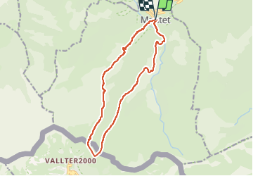

Length
15 km

Max alt
2425 m

Uphill gradient
984 m
Km-Effort
28 km

Min alt
1477 m

Downhill gradient
982 m
Boucle
Yes
Creation date :
2023-05-24 11:47:36.316
Updated on :
2023-05-24 11:47:38.514
6h24
Difficulty : Very difficult

FREE GPS app for hiking
 SityTrail
IGN / Geographical institutes
SityTrail Plus
The world is yours!
About
Trail Walking of 15 km to be discovered at Occitania, Pyrénées-Orientales, Mantet. This trail is proposed by FAUCET.
Positioning
Country:
France
Region :
Occitania
Department/Province :
Pyrénées-Orientales
Municipality :
Mantet
Location:
Unknown
Start:(Dec)
Start:(UTM)
443016 ; 4703005 (31T) N.
Comments