


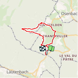
Col de Bannstein-Wintzfelden-Thannwiller-Col du Bannstein

patrickbeyrath
User

Length
11.1 km

Max alt
694 m

Uphill gradient
471 m
Km-Effort
17.4 km

Min alt
319 m

Downhill gradient
471 m
Boucle
Yes
Creation date :
2018-10-13 05:52:53.777
Updated on :
2018-10-13 05:52:53.796
3h41
Difficulty : Medium

FREE GPS app for hiking
 SityTrail
IGN / Geographical institutes
SityTrail Plus
The world is yours!
About
Trail Walking of 11.1 km to be discovered at Grand Est, Haut-Rhin, Soultzmatt. This trail is proposed by patrickbeyrath.
Positioning
Country:
France
Region :
Grand Est
Department/Province :
Haut-Rhin
Municipality :
Soultzmatt
Location:
Unknown
Start:(Dec)
Start:(UTM)
365054 ; 5312747 (32T) N.
Comments