Trail Walking Marsac-sur-l'Isle - Marsac - Photo
© OpenStreetMap contributors
Length
Length
9.2 km
Max alt
Max alt
185 m
Uphill gradient
Uphill gradient
134 m
Km-Effort
Km-Effort  
11 km
Min alt
Min alt
77 m
Downhill gradient
Downhill gradient
133 m
Boucle
Boucle
Yes
Creation date :
2023-05-27 07:14:28.469
Updated on :
2023-05-27 10:10:40.606

(0 Reviews)

Walking
Walking
2h29
Difficulty : Easy

Scan this QR Code to open this trail in the SityTrail application

FREE GPS app for hiking

Logo SityTrail SityTrail

IGN / Geographical institutes

Download SityTrail from the App Store Download SityTrail from Google Play

Logo SityTrail SityTrail World

The world is yours!

Download SityTrail from the App Store Download SityTrail from Google Play Download SityTrail on Huawei AppGallery

About

Trail Walking of 9.2 km to be discovered at New Aquitaine, Dordogne, Marsac-sur-l'Isle. This trail is proposed by NICOLEROBERT.

Description

rando du coach intersport

Elevation profile

Positioning

Country:
France
Region :
New Aquitaine
Department/Province :
Dordogne
Municipality :
Marsac-sur-l'Isle
Location:
Unknown
Start:(UTM)
316059 ; 5006858 (31T) N.

Trails nearby

Trail Walking Champcevinel - champcevinel - Photo
Walking
NICOLEROBERT

Walking

Difficult
Champcevinel, New Aquitaine, Dordogne, France
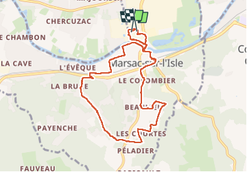
9.7 km | 12.3 km-effort
2h 48min
Yes
Trail Walking Chancelade - Circuit de l'Abbaye de Chancelade - Photo
Walking
CC.RIDER

Walking

Difficult
Chancelade, New Aquitaine, Dordogne, France
12.8 km | 18.3 km-effort
4h 9min
Yes
Trail Walking Razac-sur-l'Isle - Boucle de Razac sur l'Isle - Photo
Walking
CC.RIDER

Walking

Difficult
Razac-sur-l'Isle, New Aquitaine, Dordogne, France
13.2 km | 16.3 km-effort
3h 41min
Yes
Trail Walking Chancelade - Boucle des Andrivaux - Photo
Walking
CC.RIDER

Walking

Very difficult
Chancelade, New Aquitaine, Dordogne, France
14.8 km | 19.3 km-effort
4h 23min
Yes
Trail Running Périgueux - jour 24 CAP Jeanot - Photo
Running
jeannat

Running

Very easy
Périgueux, New Aquitaine, Dordogne, France
21 km | 23 km-effort
3h 24min
No
Trail Walking Chancelade - Boucle de la Terrassonnie - Photo
Walking
swp648

Walking

Easy
Chancelade, New Aquitaine, Dordogne, France
11.2 km | 14.7 km-effort
3h 37min
Yes
Trail Walking Coulounieix-Chamiers - boucle coulounieix - Photo
Walking
fab0202

Walking

Easy
(1)
Coulounieix-Chamiers, New Aquitaine, Dordogne, France
12.7 km | 16.4 km-effort
2h 50min
Yes
Trail Walking Champcevinel - Boucle Champcevinel par lac Lacroix - Photo
Walking
swp648

Walking

Easy
Champcevinel, New Aquitaine, Dordogne, France
12.1 km | 15.4 km-effort
2h 45min
Yes
Trail Mountain bike Périgueux - rando de la fleur de houx - Photo
Mountain bike
guycouderc

Mountain bike

Difficult
Périgueux, New Aquitaine, Dordogne, France
37 km | 48 km-effort
3h 4min
Yes


Close
My subscriptions