


Rando 3 RDP Correncon

pconte
User
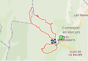

Length
9.7 km

Max alt
1312 m

Uphill gradient
270 m
Km-Effort
13.2 km

Min alt
1138 m

Downhill gradient
256 m
Boucle
No
Creation date :
2023-05-30 08:11:02.0
Updated on :
2023-05-30 14:01:29.399
4h25
Difficulty : Easy

FREE GPS app for hiking
 SityTrail
IGN / Geographical institutes
SityTrail Plus
The world is yours!
About
Trail Walking of 9.7 km to be discovered at Auvergne-Rhône-Alpes, Isère, Corrençon-en-Vercors. This trail is proposed by pconte.
Positioning
Country:
France
Region :
Auvergne-Rhône-Alpes
Department/Province :
Isère
Municipality :
Corrençon-en-Vercors
Location:
Unknown
Start:(Dec)
Start:(UTM)
698385 ; 4988835 (31T) N.
Comments