


2023-06-08 Etang la Miniere A-M

Rando MLC
User
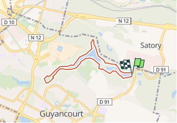

Length
6.3 km

Max alt
160 m

Uphill gradient
72 m
Km-Effort
7.3 km

Min alt
127 m

Downhill gradient
73 m
Boucle
Yes
Creation date :
2023-06-04 15:53:00.236
Updated on :
2023-06-04 15:53:53.556
1h39
Difficulty : Medium

FREE GPS app for hiking
 SityTrail
IGN / Geographical institutes
SityTrail Plus
The world is yours!
About
Trail Walking of 6.3 km to be discovered at Ile-de-France, Yvelines, Guyancourt. This trail is proposed by Rando MLC.
Positioning
Country:
France
Region :
Ile-de-France
Department/Province :
Yvelines
Municipality :
Guyancourt
Location:
Unknown
Start:(Dec)
Start:(UTM)
433556 ; 5403401 (31U) N.
Comments