Trail Walking Tusson - La randonnée de Tusson - Photo

La randonnée de Tusson

© OpenStreetMap contributors
Length
Length
8.4 km
Max alt
Max alt
147 m
Uphill gradient
Uphill gradient
85 m
Km-Effort
Km-Effort  
9.5 km
Min alt
Min alt
110 m
Downhill gradient
Downhill gradient
86 m
Boucle
Boucle
Yes
Creation date :
2023-06-08 07:04:33.867
Updated on :
2023-06-08 10:17:23.796

(0 Reviews)

Walking
Walking
3h12
Difficulty : Easy

Scan this QR Code to open this trail in the SityTrail application

FREE GPS app for hiking

Logo SityTrail SityTrail

IGN / Geographical institutes

Download SityTrail from the App Store Download SityTrail from Google Play

Logo SityTrail SityTrail World

The world is yours!

Download SityTrail from the App Store Download SityTrail from Google Play Download SityTrail on Huawei AppGallery

About

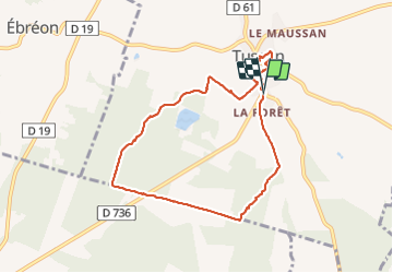
Trail Walking of 8.4 km to be discovered at New Aquitaine, Charente, Tusson. This trail is proposed by alainjoseph6.

Description

Une belle balade avec la visite du magnifique village de Tusson

Elevation profile

Photos

Positioning

Country:
France
Region :
New Aquitaine
Department/Province :
Charente
Municipality :
Tusson
Location:
Unknown
Start:(UTM)
272732 ; 5090483 (31T) N.

Trails nearby

Trail Walking Luxé - LUXÉ  (Le lac des SAULES) - Photo
Walking
alainjoseph6

Walking

Easy
Luxé, New Aquitaine, Charente, France
9.1 km | 10.5 km-effort
2h 37min
Yes
Trail Other activity Charmé - charme lgv - Photo
Other activity
zette19

Other activity

Very easy
Charmé, New Aquitaine, Charente, France
14.7 km | 17.2 km-effort
4h 6min
Yes


Close
My subscriptions