


J4 château detour

ophness
User
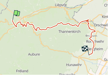

Length
30 km

Max alt
897 m

Uphill gradient
1023 m
Km-Effort
44 km

Min alt
201 m

Downhill gradient
1247 m
Boucle
No
Creation date :
2023-06-09 11:47:20.0
Updated on :
2023-06-09 11:47:21.209
5h51
Difficulty : Very difficult

FREE GPS app for hiking
 SityTrail
IGN / Geographical institutes
SityTrail Plus
The world is yours!
About
Trail Horseback riding of 30 km to be discovered at Grand Est, Haut-Rhin, Sainte-Marie-aux-Mines. This trail is proposed by ophness.
Positioning
Country:
France
Region :
Grand Est
Department/Province :
Haut-Rhin
Municipality :
Sainte-Marie-aux-Mines
Location:
Unknown
Start:(Dec)
Start:(UTM)
364391 ; 5345682 (32U) N.
Comments